Devrent (Imagination) Valley
Devrent Valley Cappadocia Guide
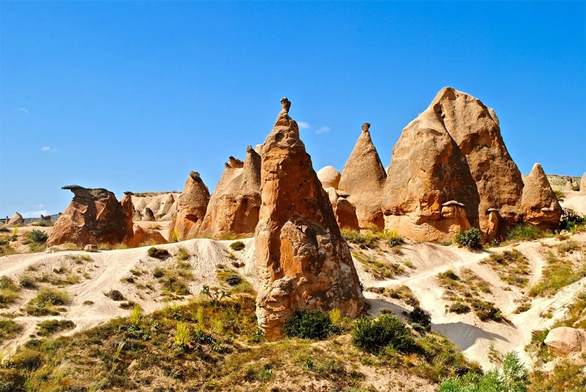
Devrent Valley, also known as Imagination Valley or Hayal Vadisi, is one of the most unusual natural landscapes in Cappadocia. Instead of churches, cave houses or a marked museum route, the valley offers a field of volcanic formations that appear to change shape as you move around them.
Camel Rock is the famous roadside attraction, but Devrent becomes more interesting when visitors look beyond the first formation and spend time exploring the surrounding ridges and shallow ravines.
Devrent is best planned as a short geology and landscape stop rather than a major archaeological visit. Most first-time visitors need 45 to 90 minutes to see Camel Rock and explore a broader section without rushing.
The area is open, exposed and only partly organized around visitor movement. Loose volcanic ground, roadside traffic and unmarked side paths matter more here than ticket lines or museum opening hours.
Choose a clear turnaround point before moving away from the road. There is no official loop that guarantees a return to the same parking position.
How to Plan a First Visit to Devrent Valley
Begin with Camel Rock, then move onto broad established ground to view the same formation from several angles. This immediately shows how much Devrent depends on perspective.
Allow at least 45 minutes when the valley is an important stop. A 15-minute bus break is enough for one photograph but not enough to understand the surrounding formations.
Wear shoes with grip and carry water. Fine volcanic dust, loose gravel and exposed sun can make a short walk more tiring than its distance suggests.
Save the vehicle position before leaving the roadside area. Similar ridges and shallow channels can make the return direction less obvious after moving deeper into the landscape.
Avoid the site during thunderstorms, strong wind or severe winter ice. The open ground provides little shelter and the powdery surface can become difficult to judge.
Why Devrent Is Called Imagination Valley
Devrent has no single historical monument that everyone comes to see. The experience depends on what each visitor recognizes in the rocks.
From different angles, the same formation may resemble a bird, seal, reptile, face, hand or completely abstract sculpture. Moving only a few meters can make the original shape disappear and reveal something new.
These figures are modern visual interpretations. The rocks were not carved to represent animals or people.
This makes Devrent different from most Cappadocia attractions. There is no correct order, fixed story or official list of formations. The valley works like a natural sculpture garden shaped by erosion and completed by the viewer's imagination.
The names used for individual shapes are informal visual labels rather than archaeological identifications. A guide may see a dolphin where another visitor sees a bird or no recognizable figure at all.
This is why moving around a formation matters more than photographing it from one marked position. Distance, side light and background separation can change the perceived shape completely.
Children often engage well with the landscape because there is no required historical sequence, but they still need close supervision on loose slopes and near the road.
Camel Rock
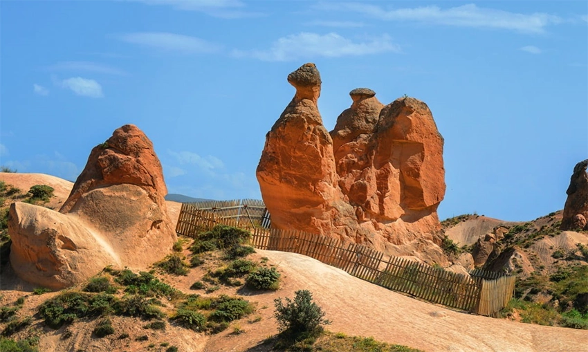
Camel Rock is the best-known formation in Devrent Valley. From its recognized side profile, the raised neck, head and body resemble a resting camel.
The formation is completely natural. Its shape developed because different parts of the volcanic rock resisted erosion at different rates.
The camel profile appears most clearly from a limited side angle. From the front or rear, the familiar neck and body may disappear.
Look for the complete outline rather than using only digital zoom. The surrounding space helps the eye separate the head, neck and resting body.
Do not touch narrow sections or place objects against the rock for scale. Repeated contact and climbing accelerate wear around an already recognizable formation.
Can You Walk Up to Camel Rock?
Camel Rock may be surrounded by a protective boundary designed to reduce climbing, touching and erosion around its narrow sections. The exact layout can change according to current site management.
Visitors should not expect to stand directly against the formation simply because older photographs show people doing so.
Related Tours
Popular experiences for this destination

Classic Car Tour Cappadocia
Step into nostalgia with a vintage classic car ride through Cappadocia…
Nostalgic Electric Car Tour Cappadocia
Ride eco-friendly nostalgic electric cars through Cappadocia’s valleys…
Professional Photo Shoot Cappadocia
Capture your Cappadocia moments with a guided professional photo shoot…
 Balloon
Balloon Watching Tour Cappadocia
Watch the magical sight of hundreds of hot air balloons rising at sunr…
 Red Tour
Red Tour Cappadocia
Discover Göreme Open-Air Museum, Avanos pottery workshops, and breatht…
 Adventure
Horseback Riding Tour Cappadocia
Experience Cappadocia on horseback, riding through valleys, hidden tra…
 Adventure
Trekking Tours Cappadocia
Hike Cappadocia’s spectacular valleys, fairy chimneys, and cave dwelli…
 Balloon
Cappadocia Hot Air Balloon Tour
See Cappadocia from the air at sunrise on a professionally operated ho…
Vip Mix Tour Cappadocia
Experience the ultimate Cappadocia highlights in comfort-historic vall…
 Adventure
ATV Tour Cappadocia
Ride powerful ATVs through Cappadocia’s unique valleys, fairy chimneys…
 Green Tour
Green Tour Cappadocia
Explore Derinkuyu underground city, the beautiful Ihlara Valley, and S…
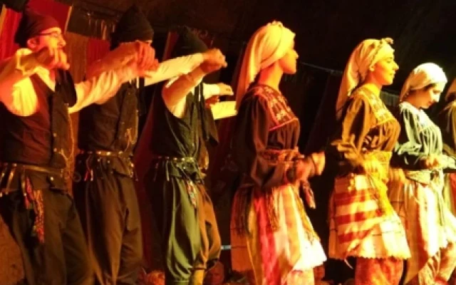
Turkish Night Show Cappadocia
Enjoy a traditional Turkish dinner with live music, folk dances, and w…
The best view is still available from outside the protected area. Move sideways until the neck and body align clearly rather than attempting to cross a barrier for a closer photograph.
A barrier is part of current conservation management, not an obstacle to be crossed when staff are absent. Older photographs do not prove that direct access remains permitted.
Keep children and photography equipment outside the protected boundary. The formation can be photographed clearly without entering the enclosed area.
Do Not Leave After the Camel Rock Photo
Most organized groups stop near Camel Rock, take photographs and return to the vehicle. This creates the impression that Devrent is a single roadside formation.
The surrounding landscape contains many less obvious shapes hidden among ridges, gullies and freestanding rocks. Walk beyond the immediate bus stop area on visible ground and allow your viewing angle to change.
The formations farther from the road may not have official names or signs. That is part of the experience. Instead of searching for a checklist, look for profiles, negative spaces and shadows that suggest different figures.
Do not treat one exact distance from Camel Rock as a guaranteed secret zone. Paths, erosion and access conditions can change. Continue only along ground that is clearly open and safe.
Look back toward the road regularly. The roadside vehicles provide the easiest orientation reference when the formations begin to overlap.
Do not follow a narrow channel simply because footprints continue into it. Some tracks are created by repeated visitors rather than by formal route planning.
The quieter formations are not necessarily farther away. Moving to the opposite side of one ridge can remove the roadside crowd from view without requiring a long walk.
Use a turnaround time as well as a destination. This prevents the visit from expanding into an uncertain cross-country route.
Roadside Stop or Deeper Exploration?
| Experience | Approximate Time | Difficulty | What You Will See |
|---|---|---|---|
| Camel Rock Photo Stop | 20 to 30 minutes | Very easy | Camel Rock and the main roadside formations |
| Main Imagination Valley Walk | 45 to 90 minutes | Easy to moderate | Changing rock profiles, shallow ravines and quieter viewpoints |
| Slow Landscape Exploration | 1.5 to 2 hours | Moderate on loose slopes | Less obvious formations beyond the principal tour-group area |
These time ranges are practical estimates rather than official routes. Parking location, crowd levels, photography and loose ground can change the final duration.
Deeper exploration should remain an out-and-back visit unless a guide or current route plan confirms another exit.
Devrent is not a formal long-distance hiking route. There is no single marked loop that every visitor must complete.
The Red Tour Crowd Pattern
Devrent is commonly included in northern Cappadocia sightseeing routes, especially the Cappadocia Red Tour.
Several group vehicles may arrive close together, creating a short period when Camel Rock and the roadside paths become crowded. Midday is often busier because many tours reach Devrent after visiting another northern attraction, but no exact daily crowd schedule can be guaranteed.
Tour itineraries, departure times and stop orders differ between operators.
Some Red Tour programs stop only for Camel Rock, while others allow time to move among nearby formations. Ask for the actual stop length when Devrent is a priority.
Large groups often concentrate around the first recognizable profile. The rest of the open landscape can feel much quieter even during the same period.
Tour vehicles, taxis and private cars share a limited roadside area. Remain alert when crossing between the parking side and viewing ground.
How to Avoid the Main Group Wave
Independent visitors generally have a better chance of finding quieter conditions earlier in the morning or later in the afternoon.
When a group arrives, there is no need to compete for the same Camel Rock angle. Walk toward another open section and return after the group has moved on. Many organized stops are relatively short.
Do not stand in the road or vehicle turning area while waiting for a clear photograph. A safer angle from firm ground is preferable to a perfectly empty background.
Independent visitors should avoid parking in spaces needed by larger vehicles. Follow current signs and local instructions.
Devrent's Specific Ground Conditions
The main challenge at Devrent is not distance. It is the surface.
The exposed ground contains fine volcanic dust, loose gravel and smooth slopes. A section that looks firm from a distance may become slippery when crossed at an angle.
The powdery surface can also become airborne when the wind increases or when many people walk through the same narrow area.
There is little shade across the principal formation zone. Services, seating and refreshments should not be expected once you move away from the roadside stopping area.
Avoid climbing directly up narrow formations. The rock is softer and more fragile than its solid appearance suggests.
Descending can be harder than climbing because fine dust reduces grip on smooth slopes. Use broad lines and avoid crossing diagonally over steep surfaces.
After rain, volcanic soil may become sticky or slippery. Walking around mud through untouched ground creates new erosion lines.
During strong wind, dust can affect visibility, eyes and camera equipment. Eye protection and a lens cloth are useful in dry periods.
There are few reliable facilities beyond the main roadside area. Use toilets and purchase water before leaving Avanos, Ürgüp or another serviced stop.
When the Rock Shapes Are Easiest to See
Devrent's figures depend heavily on shadows.
When sunlight is directly overhead, small details disappear and the formations can appear flatter. Lower morning or late-afternoon light creates stronger separation between heads, necks, wings and facial profiles.
There is no fixed daily photography window because sunset time changes throughout the year. The useful rule is simple: angled light reveals more shape than flat midday light.
Late afternoon also gives the pale and pink volcanic surfaces a warmer color. Morning can offer clearer air and fewer organized groups.
Side light is especially useful for profiles because it separates small projections from the background. A shape that is invisible at midday may become clear when one edge falls into shadow.
Cloudy light can still work well for close rock texture, but it reduces the contrast that creates animal-like silhouettes.
Do not remain on unfamiliar slopes until darkness. Devrent is not organized as a protected sunset platform, and loose ground becomes difficult to read quickly.
How Devrent's Shapes Formed
Devrent developed within Cappadocia's ancient volcanic deposits. Water, frost, gravity, wind and natural fractures gradually removed weaker material while more resistant sections remained.
Small differences inside the rock produced the irregular towers, curved profiles and narrow connections that visitors now interpret as animals and faces.
The formations are still changing. A profile visible today may become less recognizable as erosion continues.
The wider Cappadocian landscape developed from volcanic deposits including ignimbrite, tuff and sedimentary layers. Their hardness, thickness, fractures and position on the slope affect how each formation develops.
Water and runoff remove material along weak zones, while frost, temperature change and gravity widen cracks. Wind can move loose particles but should not be presented as the only shaping force.
Some fairy chimneys form where a harder cap protects softer material below. Devrent also contains irregular uncapped forms whose appearance depends on joints, local resistance and advanced erosion.
Natural change is unavoidable, but climbing and repeated touching add preventable pressure. The best conservation action for an open site is to use existing ground and respect barriers.
Read the guide to the formation of Cappadocia's fairy chimneys for the complete geological explanation.
Is Devrent a Museum or Archaeological Site?
No. Devrent is primarily a natural landscape.
Unlike Zelve, it is not visited for a former rock-cut settlement. Unlike Göreme Open-Air Museum, it does not offer a concentrated group of painted Byzantine churches.
This distinction helps set the correct expectation. Devrent is about visual interpretation, geology and movement through an open landscape rather than historical interiors.
The absence of a museum circuit does not mean the landscape lacks value or needs artificial stories. Its significance comes from active geomorphology and the way human perception interprets natural forms.
Do not invent ancient legends for individual rocks unless a reliable local tradition is documented. Most animal names are modern tourism descriptions.
Visitors primarily interested in Byzantine churches or cave settlement should spend more time at Zelve or Göreme Open-Air Museum and use Devrent as a contrasting natural stop.
Is Devrent Valley Free?
Devrent is generally experienced as an open natural area rather than a ticketed museum.
Parking, roadside stopping arrangements or locally managed access conditions may change. Check current signs instead of relying on an old price or access report.
A free natural landscape does not mean visitors can climb every formation or enter every surrounding track.
Roadside parking, barriers and managed zones can change because of safety or conservation work. Current signs should override an old route description.
Related Tours
Popular experiences for this destination
Classic Car Tour Cappadocia
Step into nostalgia with a vintage classic car ride through Cappadocia…
Nostalgic Electric Car Tour Cappadocia
Ride eco-friendly nostalgic electric cars through Cappadocia’s valleys…
Professional Photo Shoot Cappadocia
Capture your Cappadocia moments with a guided professional photo shoot…
BalloonBalloon Watching Tour Cappadocia
Watch the magical sight of hundreds of hot air balloons rising at sunr…
Red TourRed Tour Cappadocia
Discover Göreme Open-Air Museum, Avanos pottery workshops, and breatht…
AdventureHorseback Riding Tour Cappadocia
Experience Cappadocia on horseback, riding through valleys, hidden tra…
AdventureTrekking Tours Cappadocia
Hike Cappadocia’s spectacular valleys, fairy chimneys, and cave dwelli…
BalloonCappadocia Hot Air Balloon Tour
See Cappadocia from the air at sunrise on a professionally operated ho…
Vip Mix Tour Cappadocia
Experience the ultimate Cappadocia highlights in comfort-historic vall…
AdventureATV Tour Cappadocia
Ride powerful ATVs through Cappadocia’s unique valleys, fairy chimneys…
Green TourGreen Tour Cappadocia
Explore Derinkuyu underground city, the beautiful Ihlara Valley, and S…
Turkish Night Show Cappadocia
Enjoy a traditional Turkish dinner with live music, folk dances, and w…
Do not move ropes, stones or protective markers to create a photograph. Their purpose may not be obvious from one angle.
Private agricultural tracks and surrounding rural land may begin close to the open visitor area. Free entry does not create access rights across every dirt road.
How to Reach Devrent Valley
Devrent lies on the northern Cappadocia road network connecting Avanos, Zelve, Paşabağ and Ürgüp.
By Car or Taxi
A rental car, taxi or private driver provides the simplest independent access.
Ask for Devrent Valley or Camel Rock and confirm that the driver is taking you to the main roadside formation area.
Use recognized stopping spaces. The road can become congested when several tour buses arrive together, so do not leave a vehicle where it blocks through traffic.
Save the parking position before walking away. The road may disappear behind low ridges after only a short distance.
When using a taxi, agree on waiting time and pickup position before the driver leaves. Finding another vehicle beside the road cannot be guaranteed.
Check the return direction before losing mobile service. Downloading the road map is useful when continuing toward Avanos, Paşabağ or Ürgüp.
By Public Transport
Do not assume that a regular minibus will stop beside Camel Rock or return at a convenient time.
Anyone attempting the journey by local transport should confirm the current route, roadside drop-off point and return connection before leaving Avanos or Ürgüp.
Walking along the main road from a distant minibus stop is not a good general sightseeing plan because traffic, shoulders and return timing can be uncertain.
A taxi, rental car, private driver or organized tour remains the more practical choice for most visitors.
By Red Tour
The Cappadocia Red Tour commonly combines Devrent with other northern Cappadocia attractions.
Some programs provide only enough time for Camel Rock, while others allow a short landscape walk. Confirm the stop duration before booking when Devrent is an important part of your day.
Also confirm whether the route includes Paşabağ, Zelve, Avanos or Göreme Open-Air Museum. Red Tour names do not guarantee one fixed itinerary.
Entrance fees normally concern managed sites on the route rather than Devrent itself, but package inclusions should still be checked.
Devrent, Paşabağ or Zelve?
| Location | Main Reason to Visit | Access Type | Suggested Time |
|---|---|---|---|
| Devrent Valley | Animal-like and human-like natural rock formations | Generally an open roadside landscape | 30 to 90 minutes |
| Paşabağ Monks Valley | Tall capped and multi-headed fairy chimneys | Managed archaeological and natural visitor site | 1 to 1.5 hours |
| Zelve Open-Air Museum | Cave homes, churches, a mosque and a former rock-cut village | Ticketed open-air museum | 2 to 3 hours |
Current entrance prices and Museum Pass conditions for managed sites can change. Confirm them before traveling.
Choose Devrent for visual interpretation and geology, Paşabağ for large capped chimneys and Zelve for the relationship between landscape and former settlement.
Visiting all three can make sense because they answer different questions. Rushing through each one as the same type of fairy-chimney stop removes those differences.
Places to Visit Near Devrent Valley
Paşabağ Monks Valley
Paşabağ Monks Valley is the stronger choice for visitors who want to walk among large capped fairy chimneys.
Zelve Open-Air Museum
Zelve Open-Air Museum combines volcanic formations with homes, churches, pigeon houses, agricultural structures and the remains of a complete village.
Avanos
Avanos adds pottery workshops, historic stone streets and riverside walking beside the Kızılırmak.
Ürgüp
Ürgüp is a practical base for reaching Devrent from the south and offers restaurants, accommodation and wine-related stops.
A balanced northern route normally combines Devrent with one or two managed sites and Avanos. Do not overload the day with every central Cappadocia valley.
Can You See Balloons From Devrent?
Balloons may occasionally appear in the wider sky, but Devrent is not a reliable primary balloon viewpoint.
Flight direction changes according to wind and operational decisions. The surrounding formations can also limit the open view toward the main Göreme flight area.
Visitors whose priority is balloon watching should choose a recognized viewpoint closer to central Göreme.
Read the Cappadocia hot-air balloon guide before selecting a sunrise location.
Entering Devrent before dawn adds road and footing risks without guaranteeing a useful balloon position. A central Göreme viewpoint is normally more reliable for this purpose.
Devrent is stronger in angled daylight when shadows reveal the rock profiles.
Explore Devrent on the Cappadocia Red Tour
Devrent is most useful as part of a northern Cappadocia route because it provides a completely different experience from the nearby ticketed sites.
Paşabağ shows the classic capped fairy chimney form. Zelve explains how people lived within volcanic cliffs. Devrent shows what happens when natural erosion produces forms that the human mind turns into animals, faces and imaginary sculptures.
A Cappadocia Red Tour can connect these locations without requiring separate parking and route planning.
Not every Red Tour follows the same itinerary. Confirm whether the program includes Devrent, Paşabağ, Zelve or Göreme Open-Air Museum, how long each stop lasts and whether entrance tickets and lunch are included.
A private route is more useful when visitors want a longer Devrent walk or photography time beyond Camel Rock. Shared tours normally prioritize a concise roadside stop.
Use the guide to getting to and around Cappadocia when comparing a rental car, taxi and tour.
Best Time and Seasonal Conditions
Spring
Cooler temperatures can suit longer exploration, but rain may leave soft mud in shallow channels and on sloping ground.
Summer
Begin earlier or visit later in the day. The main formation zone has little shade, and exposed ground can become hot.
Autumn
Cooler air and generally dry surfaces often provide comfortable walking and strong late-afternoon texture.
Winter
Snow changes the visual profiles, but ice can make smooth volcanic slopes unsafe even when the main road is clear.
Accessibility and Family Planning
Camel Rock can be viewed close to the roadside, but the wider landscape is uneven, dusty and not designed as an accessible paved circuit.
Visitors with limited mobility can focus on the principal formation area and avoid loose side slopes. Ask the driver to use the closest recognized stopping point.
Families can enjoy the imagination theme, but children should remain close near the road, barriers and fragile formations.
Strollers are suitable only on selected firm roadside ground. They are not practical for the loose interior paths.
Photography at Devrent Valley
Move sideways before moving closer. Perspective is more important than distance when trying to reveal a recognizable profile.
Use people or neighboring formations for scale without placing anyone against the rock. A moderate zoom can separate the subject from a busy background.
Keep tripods outside vehicle routes and narrow walking lines. Do not climb a slope only to remove another visitor from the frame.
Drone use depends on current aviation, heritage and local restrictions. An open natural area should not be treated as automatic permission.
Common Devrent Valley Planning Mistakes
- Leaving after one Camel Rock photograph: The surrounding ridges provide the main imagination experience.
- Expecting a marked hiking loop: Devrent has open exploratory ground rather than one official circuit.
- Climbing fragile formations: Soft volcanic rock and loose slopes can fail under pressure.
- Planning only by distance: Dust and diagonal slopes can make a short route tiring.
- Parking on the road: Tour buses and through traffic need clear access.
- Arriving at midday for photography: Flat overhead light hides many profiles.
- Inventing historical stories: Most animal labels are modern visual interpretations.
- Depending on public transport: Return connections beside the valley may be unreliable.
Questions Travelers Ask About Devrent Valley
How long should you spend in Devrent?
Allow 20 to 30 minutes for Camel Rock alone and 45 to 90 minutes for a broader first visit.
Is Devrent Valley free?
It is generally experienced as an open natural landscape, but parking or local access arrangements can change.
Is Camel Rock natural?
Yes. The profile developed through differential erosion and is not a carved sculpture.
Can you walk through the valley?
Yes, on open and clearly safe ground. There is no single official loop, so use an out-and-back plan and save the parking position.
Is Devrent suitable for children?
Yes, especially for the imagination theme, but close supervision is needed near traffic, barriers and loose slopes.
Are there toilets or cafés?
Roadside services may be limited or seasonal. Use facilities and purchase water before arriving.
Is Devrent the same as Paşabağ?
No. Devrent is known for irregular imagination-based profiles, while Paşabağ is known for large capped and multi-headed fairy chimneys.
Can you see balloons from Devrent?
They may appear occasionally, but Devrent is not a reliable primary balloon viewpoint.
How Devrent Fits Into a Cappadocia Itinerary
Camel Rock explains why Devrent became famous, but it does not explain the complete valley.
The real experience begins when visitors stop looking for one recognized shape and start moving around the landscape. A rock may resemble an animal from one direction, a human face from another and nothing familiar at all from the opposite side.
Devrent does not need a church, legend or artificial photo installation to hold attention. Its value comes from the interaction between natural erosion and human imagination.
Spend enough time to move beyond the roadside crowd, but do not turn the visit into an unsafe climb. The best formation is often not the one with a name. It is the one you recognize before anyone else points it out.
For most first-time visitors, Devrent works best between Paşabağ, Zelve and Avanos on a northern Cappadocia day. Its role is to provide a natural and imaginative contrast to ticketed historical sites.
A strong visit uses perspective rather than climbing, treats Camel Rock as the beginning rather than the entire destination and returns to the vehicle before the open terrain becomes confusing.
Devrent does not require a long story or invented legend. Its value comes from active erosion, changing light and the different images each visitor sees in the same rock.