Formation of the Fairy Chimneys
How Cappadocia's Fairy Chimneys Formed: Geology, Erosion and What to Look For
Cappadocia's fairy chimneys developed through differential erosion. Rainwater, concentrated surface runoff, temperature changes, gravity and wind removed relatively soft volcanic rock, while harder layers or resistant blocks protected parts of the material beneath them. The surviving sections gradually became isolated cones, pillars and capped towers.
This process did not begin with one eruption, and the volcanic deposits cannot be assigned to one mountain. Repeated explosive events spread ash, pumice and rock fragments across Central Anatolia. Much later, water and weathering cut valleys into those deposits and separated the remaining ridges into individual formations.
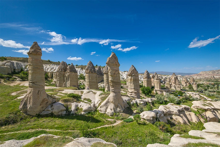
The Cappadocia landscape therefore records two connected geological stages. Volcanic activity first built the plateau layer by layer. Erosion then followed slopes, fractures and drainage channels, exposing rock units with different levels of resistance.
The formations visible today are not finished objects. Every cap, crack and pale erosion channel belongs to an active landscape that continues to change after heavy rain, winter frost and seasonal temperature shifts.
What Is a Fairy Chimney?
A fairy chimney is an erosion landform created when a section of relatively resistant rock protects softer material beneath or around it. As surrounding material is removed, an isolated column, cone or tower remains standing.
Fairy chimneys do not all have the same shape. Depending on the volcanic unit, slope, fractures and style of erosion, they may appear as:
- Pointed cones without a separate visible cap
- Tall pillars topped by a resistant stone block
- Wide mushroom-shaped formations
- Multi-headed formations with several upper sections
- Irregular towers influenced by cracks and volcanic gas escape structures
The term describes their appearance rather than one single geological structure. A formation at Paşabağ may have a different internal composition and erosion history from one in Zelve, Devrent or the valleys near Ürgüp.
This is why a single diagram can explain the general process but cannot describe every fairy chimney in Cappadocia perfectly.
Viewpoint and scale also matter. A narrow pillar may appear completely isolated from one angle but remain attached to a wider ridge behind it. Moving around the same formation often reveals that the first silhouette did not show its full structure.
What Are Cappadocia's Fairy Chimneys Made Of?
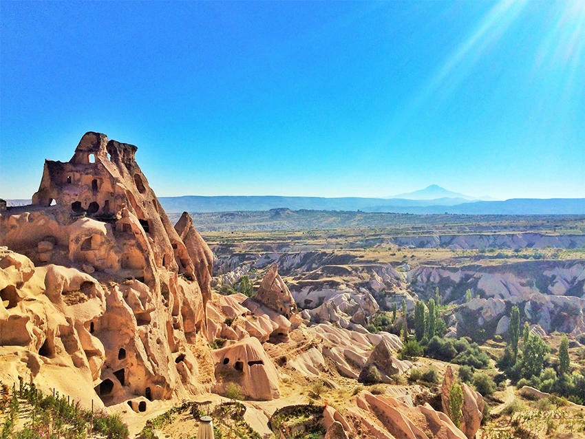
The fairy chimney landscape is strongly associated with volcanic deposits called ignimbrites. These deposits were produced by hot, ash-rich volcanic flows that traveled across the land during major explosive eruptions.
Ignimbrite may contain volcanic ash, pumice fragments, crystals and pieces of older rock. After deposition, this material compacted and hardened into thick sheets with different strengths, textures and degrees of welding.
The word tuff is commonly used in visitor guides to describe Cappadocia's soft volcanic rock. In geological terms, however, the region contains several volcanic and sedimentary units rather than one continuous and uniform layer of tuff.
Some ignimbrites are strongly welded and relatively resistant. Others are weakly welded or nonwelded and can be removed more easily by water and weathering. Many of Cappadocia's most recognizable fairy chimneys developed in these softer, weakly welded or nonwelded deposits.
What Does the Rock Look Like at Close Range?
In many valleys, the pale cream, white or light gray surfaces appear dusty and finely textured. Small pieces that have already fallen naturally may look sandy, porous or powdery because the rock contains compacted volcanic ash and pumice.
You do not need to touch or scratch a fairy chimney to understand its texture. Look at naturally exposed surfaces, loose material already lying on the recognized path and fresh erosion marks created by rainfall.
The contrast between a smooth pale wall and a darker, harder upper layer often reveals where the erosion resistance changes.
Freshly exposed surfaces may look lighter than rock that has remained open to the weather for years. This color difference does not automatically indicate a separate volcanic unit, so texture, thickness and position should be considered together.
Tuff and Ignimbrite in Cappadocia: What Is the Difference?
Visitors often hear the words tuff and ignimbrite used as though they mean exactly the same thing. They are related, but they are not always interchangeable.
Tuff is a broad term for rock formed from consolidated volcanic ash and related fragments. Ignimbrite is more specifically connected with deposits created by hot, ground-hugging pyroclastic density currents during explosive eruptions.
Ignimbrites can be welded, partly welded or nonwelded. Their physical character depends on temperature, composition, deposit thickness and the way the material cooled after emplacement.
This difference helps explain why one part of a valley may form smooth cones while a nearby layer creates steep cliffs, darker ledges or more resistant caps.
Field observation: When walking through Paşabağ, Zelve or Göreme, compare the soft-looking body of a formation with its upper section. A change in color, texture or fracture pattern may indicate a change between volcanic layers with different erosion resistance.
Which Volcanoes Created the Cappadocia Landscape?
Mount Erciyes, Mount Hasan and the Göllüdağ volcanic area are often included in short explanations of Cappadocia's geology. All belong to the wider Central Anatolian volcanic province, but they did not contribute identical material at the same time.
It is inaccurate to claim that every layer around Göreme, Ürgüp and Avanos came directly from the two large volcanic cones visible on the horizon. Geological studies identify several ignimbrite sheets with different ages, compositions, thicknesses and probable source areas.
Some deposits are linked with major explosive centers and caldera systems rather than with a single modern-looking mountain. The source of an ash-rich flow may also lie far from the place where the deposit is now exposed.
The most reliable summary is that Cappadocia was built by multiple volcanic sources and repeated eruptions. Mount Erciyes and Mount Hasan are important parts of that regional history, but they are not a complete explanation for every fairy chimney.
Celal Şengör's interpretation: Turkish geologist Prof. Dr. Celal Şengör has noted that Cappadocia's defining tuff landscape should not be explained as the direct product of Mount Erciyes or Mount Hasan alone. He instead points to large caldera-forming eruptions in the wider Niğde–Nevşehir volcanic region as a key source of the ash-rich deposits. This interpretation supports the broader geological picture of multiple volcanic centers and repeated explosive events across Central Anatolia.
Related Tours
Popular experiences for this destination
 Adventure
Trekking Tours Cappadocia
Hike Cappadocia’s spectacular valleys, fairy chimneys, and cave dwelli…
 Adventure
ATV Tour Cappadocia
Ride powerful ATVs through Cappadocia’s unique valleys, fairy chimneys…
 Adventure
Horseback Riding Tour Cappadocia
Experience Cappadocia on horseback, riding through valleys, hidden tra…
Pottery Workshop Cappadocia
Learn the ancient art of pottery from Avanos masters, try shaping clay…
 Red Tour
Red Tour Cappadocia
Discover Göreme Open-Air Museum, Avanos pottery workshops, and breatht…
Vip Mix Tour Cappadocia
Experience the ultimate Cappadocia highlights in comfort-historic vall…
 Balloon
Balloon Watching Tour Cappadocia
Watch the magical sight of hundreds of hot air balloons rising at sunr…
 Balloon
Cappadocia Hot Air Balloon Tour
See Cappadocia from the air at sunrise on a professionally operated ho…
Professional Photo Shoot Cappadocia
Capture your Cappadocia moments with a guided professional photo shoot…

Classic Car Tour Cappadocia
Step into nostalgia with a vintage classic car ride through Cappadocia…
 Adventure
Jeep Safari Tour Cappadocia
Take an off-road jeep adventure across Cappadocia’s rugged landscapes,…
 Blue Tour
Blue Tour Cappadocia
Explore hidden valleys, ancient churches, and cultural gems on Cappado…
This distinction becomes visible in the field. Rock color, pumice content, welding, fracture patterns and resistance can change from one valley to another because the exposed formations do not all belong to the same volcanic unit.
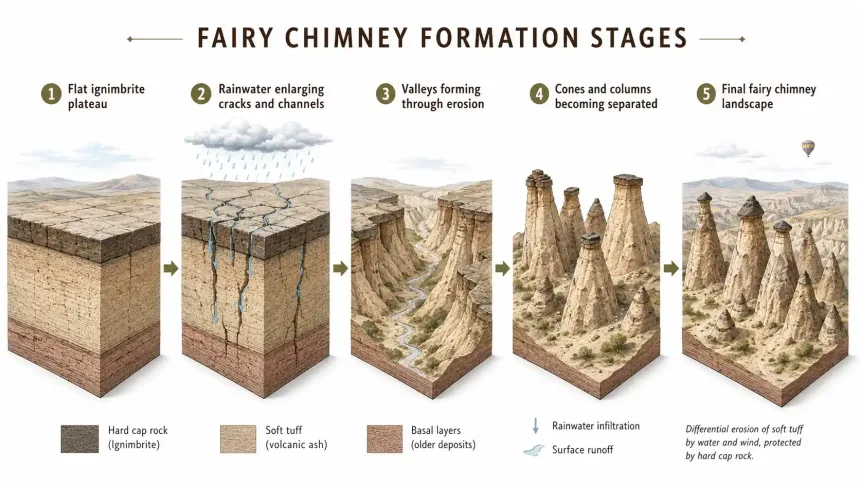
How Cappadocia's Fairy Chimneys Formed Step by Step
- Volcanic deposits covered the region: Repeated explosive eruptions spread ash, pumice and other volcanic material across the Cappadocia plateau.
- The deposits became rock: The volcanic material compacted into ignimbrite layers with different thicknesses, hardness levels and degrees of welding.
- Valleys began to develop: Rainwater and streams followed slopes, natural depressions and fractures, gradually cutting channels into the volcanic plateau.
- Soft sections eroded faster: Weakly welded rock was removed more quickly, while harder sections and protected areas remained standing.
- Individual cones became isolated: Continued erosion separated ridges into pillars, pointed cones and capped towers.
- Local features shaped each formation: Cracks, slope direction, layer thickness, resistant blocks and ancient volcanic gas escape structures influenced the final shape.
A geological study examining fairy chimneys in the Kavak, Kavak-Zelve, Zelve and Cemilköy units describes the development as a two-stage process.
First, erosion creates the topography required for fairy chimney formation. The degree of welding, thickness of the ignimbrite and steepness of the slope are especially important during this stage.
Local geological features then control the final appearance. A vertical crack, resistant block or hardened gas escape zone can determine whether the result becomes a pointed cone, capped pillar or irregular tower.
The process is not linear. A developing column may lose part of its cap, merge visually with a neighboring ridge or collapse before reaching the shape commonly shown in visitor diagrams. The surviving examples represent only part of a much larger cycle of erosion.
Why Water Shaped the Valleys More Than Wind
Wind contributes to weathering and moves loose dust after it has been detached from the surface. It is part of the continuing erosion process, but it was not the main force responsible for cutting Cappadocia's valleys.
Rainwater and concentrated surface runoff followed slopes and natural channels. During strong rainfall, water carried loose volcanic material downhill and gradually deepened drainage paths.
Streams enlarged these channels over time. As valleys became deeper, their walls became steeper and more exposed to collapse, runoff and temperature changes.
Wind then helped remove some of the loosened material and continued wearing exposed surfaces. It worked together with water, frost, chemical alteration and gravity rather than acting as the single sculptor of the landscape.
What to notice after rain: Small channels running down pale valley walls show how water concentrates instead of spreading evenly. These temporary runoff lines are a miniature version of the same process that gradually separates ridges and cones.
Why Some Fairy Chimneys Have Stone Caps
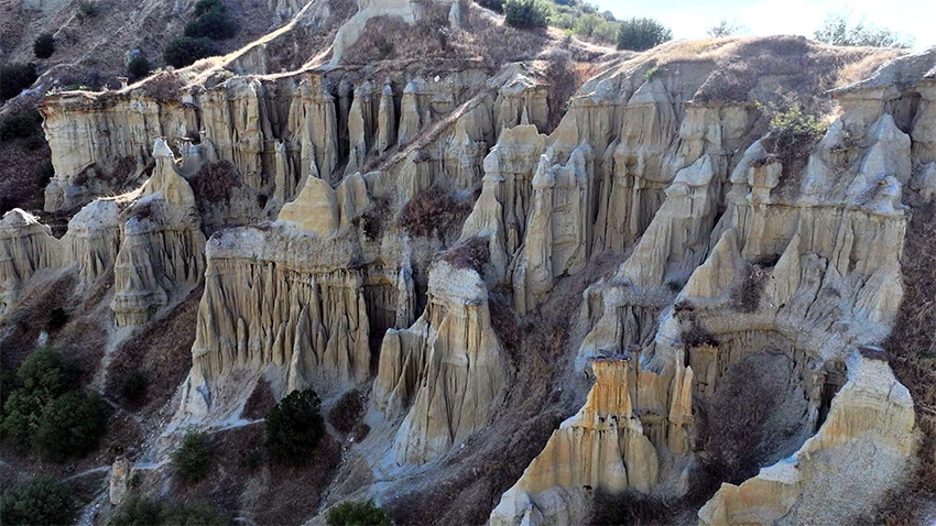
A harder cap slows the erosion of softer material beneath it. The cap works like a natural shield, reducing the amount of direct rainfall and surface runoff reaching the protected section.
Exposed rock around the protected column erodes more quickly. Over time, this difference leaves a narrow body standing beneath the more resistant upper material.
It is incorrect to describe every fairy chimney as a soft tuff pillar topped by basalt. Cappadocia contains several types of cap:
- Resistant ignimbrite layers: A harder upper volcanic unit may protect a weaker layer below.
- Pumice-rich deposits: In some formations, a cohesive pumice-rich upper section acts as the protective cap.
- Fallen volcanic blocks: At some Cemilköy formations, blocks from the younger Kızılkaya Ignimbrite protected the rock beneath them.
- No separate cap: Some fairy chimneys are almost completely conical and have no clearly detached stone hat.
At Paşabağ Monks Valley, some of the best-known chimneys developed close to the transition between the Kavak and Zelve ignimbrites. The lower body and the more resistant upper section may therefore belong to different volcanic units.
At close range, compare the contact line between these units rather than looking only at the cap. Changes in color, grain size and fracture style often explain why the upper section projects beyond the narrower body.
Why Does the Cap Not Fall Immediately?
The cap remains in place while its weight is supported by enough material beneath it and while cracks have not weakened the balance beyond a critical point.
From the ground, some caps appear impossibly large for the narrow column below. Perspective can exaggerate this effect, especially when the wider part of the cap extends beyond the visible body.
The cap does not make the formation permanent. Rain enters fractures, frost widens cracks and gravity continues pulling the block downward.
When the cap breaks or falls, the newly exposed column normally erodes more quickly. The formation may narrow, lose height or gradually disappear.
The apparent balance is temporary when measured against geological time.
Why Cappadocia's Fairy Chimneys Have Different Shapes
Rock hardness is only one part of the explanation. The final shape also depends on:
- The thickness of the ignimbrite layer
- The degree to which the volcanic deposit is welded
- The direction and steepness of the slope
- Vertical cracks and joint patterns
- Rainwater channels and surface runoff
- The presence of stronger cap material
- Ancient volcanic gas escape structures
- Underlying sedimentary layers
In parts of the Zelve Ignimbrite, ancient gas escape structures created harder vertical zones within the rock. As the weaker surrounding material eroded, these resistant zones influenced the development of irregular towers and columns.
In the Cemilköy Ignimbrite, erosion often began along vertical grooves. These grooves widened until individual conical forms separated from the surrounding rock. Some were later protected by fallen blocks of the harder Kızılkaya Ignimbrite.
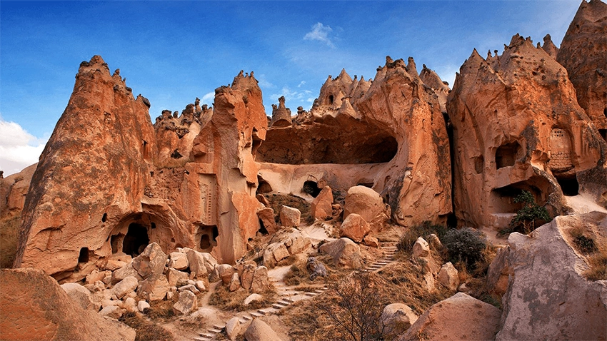
Look for Ancient Gas Escape Structures
Some ash-rich volcanic deposits still contained hot gases after they were laid down. As these gases moved upward through the deposit, they created pipe-like vertical zones and changed the surrounding material.
These areas could become harder or more resistant than the ignimbrite around them. Later erosion removed the softer rock first, leaving vertical ribs, seams and irregular projections visible on the surface.
Geological observation tip: Look carefully at tall formations and exposed walls in Zelve. Some show tube-like vertical features or harder ribs running through the softer rock. They are part of the deposit itself, not lines carved by later residents.
These features are easiest to recognize when low-angle sunlight creates shadows along the vertical surface. Midday light can flatten the same details and make them harder to notice.
How Frost, Gravity and Weathering Continue the Process
Water created the main drainage pattern and played a central role in cutting valleys, but several other processes continue to weaken exposed rock.
Water enters small fractures after rain or snowmelt. When temperatures fall below freezing, the water can expand and place additional pressure on the crack. Repeated freeze-thaw cycles gradually loosen thin layers, corners and unsupported sections.
Gravity becomes more important as valley walls steepen and the base of a formation narrows. Small fragments fall regularly, while larger blocks may move when fractures reach a critical point or when supporting material has been removed.
Chemical alteration also changes some minerals and weakens the surface. Wind carries loose particles away and abrades exposed areas, but it works within a system already shaped by runoff, stream erosion, frost and gravity.
The result remains differential erosion. Different materials and different parts of the same formation break down at unequal rates, which is why caps, ribs and isolated columns remain after nearby rock has disappeared.
How Old Are Cappadocia's Fairy Chimneys?
There is no single age that applies to every fairy chimney.
The volcanic deposits from which the formations developed are several million years old and belong to different eruption periods. The Kavak and Kızılkaya ignimbrites, for example, do not have the same age.
The visible pillars are younger than the deposits because they appeared only after erosion began cutting into those layers and isolating individual forms.
The exact age of one visible pillar is difficult to calculate because there is no single moment when erosion turns a ridge into a complete and finished fairy chimney.
It is more accurate to say that the rock is millions of years old, while the individual shape of each fairy chimney developed gradually and is still changing.
Dates published for ignimbrite units refer to the volcanic deposits, not to the moment when a familiar cone acquired its present outline. Confusing these two ages can make a fairy chimney seem as old as the eruption that produced its rock, even though its visible shape formed much later.
How Fairy Chimneys Continue to Change Today
Yes. Fairy chimney formation is not a completed process.
Rainfall, snow, frost, runoff, gravity and temperature changes continue to widen cracks and remove small amounts of material.
Some formations lose their caps or collapse. Continued erosion may also separate sections of a ridge and slowly expose new pillars.
Related Tours
Popular experiences for this destination
AdventureTrekking Tours Cappadocia
Hike Cappadocia’s spectacular valleys, fairy chimneys, and cave dwelli…
AdventureATV Tour Cappadocia
Ride powerful ATVs through Cappadocia’s unique valleys, fairy chimneys…
AdventureHorseback Riding Tour Cappadocia
Experience Cappadocia on horseback, riding through valleys, hidden tra…
Pottery Workshop Cappadocia
Learn the ancient art of pottery from Avanos masters, try shaping clay…
Red TourRed Tour Cappadocia
Discover Göreme Open-Air Museum, Avanos pottery workshops, and breatht…
Vip Mix Tour Cappadocia
Experience the ultimate Cappadocia highlights in comfort-historic vall…
BalloonBalloon Watching Tour Cappadocia
Watch the magical sight of hundreds of hot air balloons rising at sunr…
BalloonCappadocia Hot Air Balloon Tour
See Cappadocia from the air at sunrise on a professionally operated ho…
Professional Photo Shoot Cappadocia
Capture your Cappadocia moments with a guided professional photo shoot…
Classic Car Tour Cappadocia
Step into nostalgia with a vintage classic car ride through Cappadocia…
AdventureJeep Safari Tour Cappadocia
Take an off-road jeep adventure across Cappadocia’s rugged landscapes,…
Blue TourBlue Tour Cappadocia
Explore hidden valleys, ancient churches, and cultural gems on Cappado…
A visitor returning after several years may not notice a dramatic change, but smaller fractures, fallen pieces and newly exposed surfaces are part of the continuing process.
Human activity can accelerate natural damage. Climbing fragile surfaces, entering unstable cavities, carving names into the rock and leaving established paths can weaken formations already affected by erosion.
Visitors should avoid climbing fairy chimneys and should follow current paths, barriers and staff instructions.
Damage is not limited to a visible footprint. Repeated pressure can loosen grainy surfaces around carved openings and narrow ledges, while off-path movement creates new runoff channels that direct water into already weakened areas.
Natural Formations and Human-Made Spaces
The geological formations are natural. People did not construct the cones or pillars.
Communities living in Cappadocia later modified many formations by carving rooms, storerooms, stables, pigeon houses, chapels and religious cells into the soft rock.
This combination of natural geology and human adaptation is visible around Göreme, Zelve Valley and Open-Air Museum, Paşabağ and the Göreme Open-Air Museum.
Carved openings should not be mistaken for natural caves. Many were intentionally shaped, enlarged or connected by the people who used the landscape.
A naturally formed cone could therefore become a home, chapel, storage space or pigeon house without losing its geological identity.
Where the Name Fairy Chimney Comes From
The Turkish expression peri bacası literally means "fairy chimney." The name reflects the strange appearance of rock towers that seem too balanced or carefully shaped to be natural.
Local storytelling connected the formations with fairies, spirits and supernatural inhabitants. The precise historical moment when the modern term became widespread is not securely documented.
The name is therefore a poetic and folkloric description rather than a scientific geological term.
The geological explanation and the folkloric name serve different purposes. One describes the physical process, while the other records how generations of residents interpreted an unfamiliar landscape.
The Legend of the Three Beauties
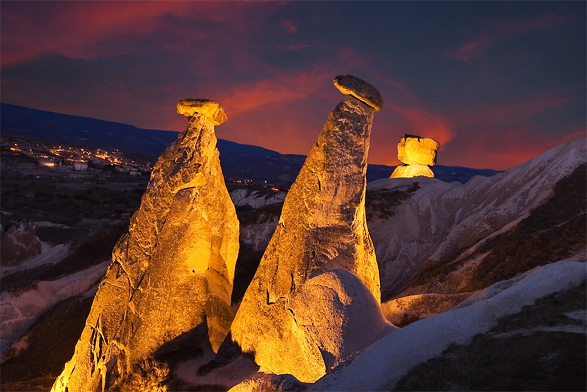
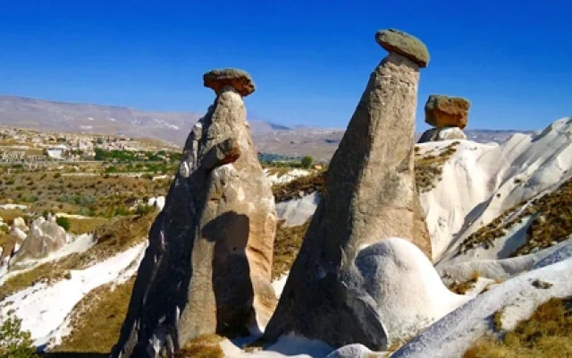
The Three Beauties near Ürgüp are among Cappadocia's most recognizable capped fairy chimneys.
One popular local legend describes the three formations as a princess, a shepherd and their child.
According to the story, the princess fell in love with the shepherd against her family's wishes. When they were threatened, the family prayed to be transformed into stone so that they could remain together.
Different versions of this story are told, and it belongs to folklore rather than documented history.
Geologically, the Three Beauties developed because more resistant upper sections protected softer volcanic material beneath them.
Their arrangement encouraged a family story that could be remembered and retold more easily than a technical geological explanation.
Best Places to See Fairy Chimneys in Cappadocia
Paşabağ Monks Valley
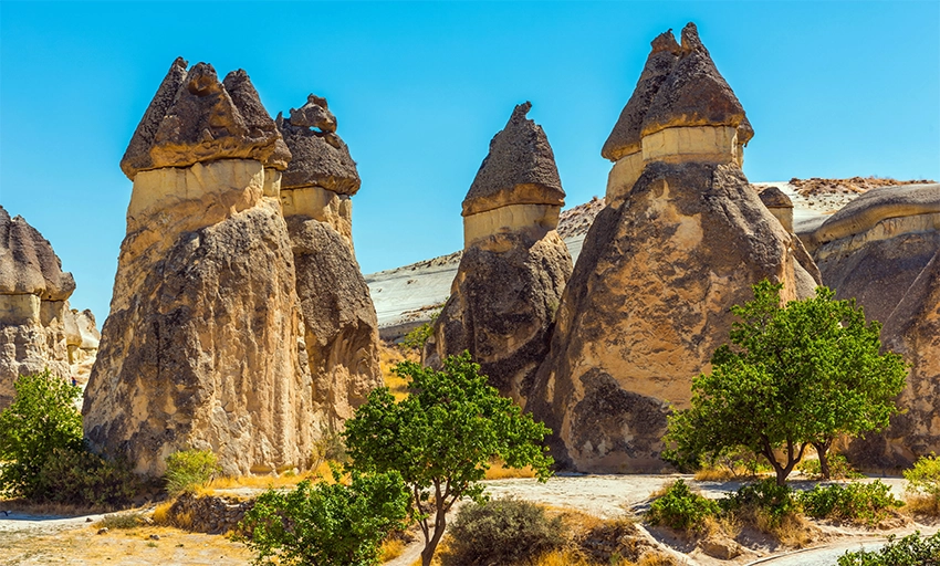
Paşabağ contains some of Cappadocia's clearest capped and multi-headed fairy chimneys.
Visitors can observe the relationship between the softer lower body, more resistant upper material and carved human spaces at close range.
This is one of the best places to understand how several heads can remain connected to the same lower formation before erosion eventually separates or destroys them.
Zelve Valley
Zelve Valley and Open-Air Museum combines eroded volcanic walls, pointed formations, carved dwellings and historic religious structures.
It is especially valuable for understanding how natural formations became part of a settlement and how geological differences produced narrow ridges, cones and irregular towers.
Zelve is also one of the strongest places to look for vertical gas escape structures and harder ribs within the ignimbrite.
The walking route crosses uneven ground and exposed slopes, so morning light is useful both for reading the rock surface and for avoiding the strongest summer heat.
Devrent Imagination Valley
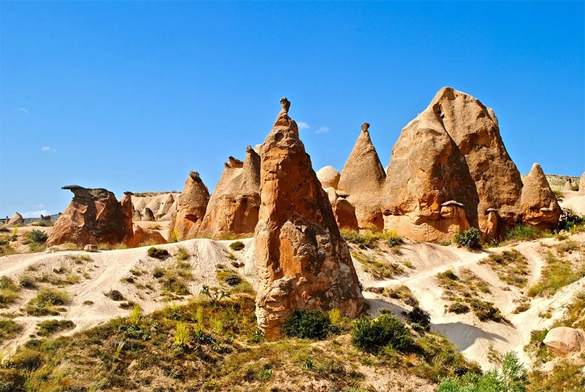
Devrent Valley is known for irregular formations that resemble animals, faces and familiar objects.
Its shapes show how differences in fractures, rock strength and erosion can create forms very different from the capped chimneys of Paşabağ.
Instead of searching only for the famous camel-shaped formation, look at the surrounding ridges and notice how small differences in resistance create noses, necks, arches and isolated towers.
Love Valley
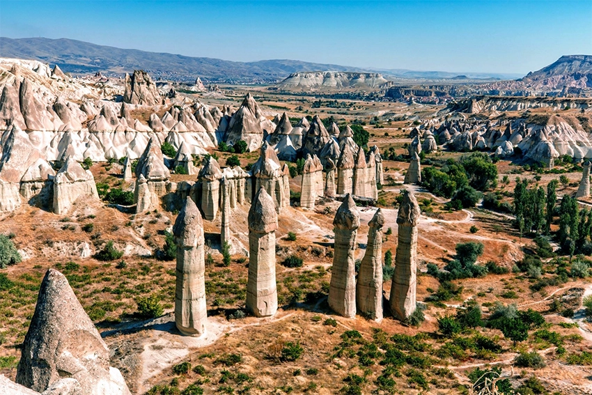
Love Valley contains tall, narrow pillars with rounded or resistant upper sections.
The valley can be viewed from panoramic points above or explored on foot through established routes.
The upper viewpoint shows the pattern of the complete valley, while the lower trail makes the scale and surface texture of the individual pillars easier to understand.
The two experiences are not interchangeable. The panorama is a short stop, while the lower route requires more time, suitable footwear and a clear plan for the exit point.
The Three Beauties
The Three Beauties provide one of the clearest roadside examples of capped fairy chimney development.
The roadside viewpoint lies close to Ürgüp and fits easily into a route that also includes central and northern Cappadocia.
Look at the contact between the wider caps and narrower bodies. This boundary helps explain how changes in rock resistance control the final silhouette.
Göreme and the Surrounding Valleys
The valleys around Göreme combine fairy chimneys, rock-cut spaces, vineyards and panoramic viewpoints.
Travelers can explore selected routes independently or join a Cappadocia trekking tour for guided geological and historical interpretation.
A guide can help distinguish natural openings, carved rooms, volcanic layers, erosion channels and later settlement features that may otherwise appear similar.
What to Look for When You See a Fairy Chimney
Instead of taking one photograph and moving immediately to the next stop, spend a few minutes reading the formation from top to bottom.
- Find the cap: Decide whether the formation has a separate block, a resistant upper layer or no obvious cap.
- Compare the colors: A change from pale cream to gray, pink or reddish rock may show a transition between volcanic units.
- Follow the cracks: Vertical joints often control where a ridge begins separating into individual columns.
- Look for water channels: Small grooves reveal where rainfall and runoff continue removing material.
- Notice carved openings: Doorways, windows and pigeon houses belong to the human history of the formation, not its original geology.
- Check the fallen material: Naturally fallen pieces beside the path help reveal the texture of the rock without touching the protected surface.
These observations make the formation easier to read as a geological record rather than only as a photograph.
How to Visit Fairy Chimneys Responsibly
- Do not climb fragile cones or capped formations.
- Stay on established paths where they are available.
- Do not enter closed or unstable rock-cut rooms.
- Do not touch, scratch, carve or write on volcanic surfaces.
- Do not remove naturally fallen rock as a souvenir.
- Wear shoes with reliable grip on loose and dusty ground.
- Avoid narrow valley routes during heavy rain or thunderstorms.
- Keep children away from unstable edges and unsupported cavities.
- Follow official signs, barriers and current drone restrictions.
The surface of a fairy chimney may look solid from a distance but can be soft, fractured and unstable at close range. Repeated touching, climbing and off-path movement accelerate the same erosion process that created the formation.
See Cappadocia's Geology on the Red Tour
Many of northern Cappadocia's best-known formations can be visited during the Cappadocia Red Tour.
Red Tour routes commonly include places such as Paşabağ, Devrent, Avanos, Göreme-area viewpoints and other northern attractions. These stops allow visitors to compare capped pillars, irregular formations, volcanic layers and settlement landscapes within the same day.
The route can vary between operators. Confirm the exact stops, museum admissions, guide language, lunch and time allowed at each location before booking.
Travelers who want to spend more time examining the geology can also choose a private route combining Paşabağ, Zelve, Devrent and the Three Beauties.
A geology-focused route benefits from longer stops and fewer locations. Comparing two formations carefully often provides more understanding than visiting many viewpoints without time to examine their layers, cracks and erosion channels.
Common Misconceptions About Cappadocia's Fairy Chimneys
Wind Alone Carved the Valleys
Wind moves dust and contributes to surface weathering, but it was not the main force that cut Cappadocia's drainage network. Rainwater, concentrated runoff and streams removed large amounts of weak volcanic material and deepened the valleys over time.
Every Formation Is Made of Solid Lava
Most classic fairy chimneys developed in ash-rich volcanic deposits called ignimbrites, not in solid lava flows. These deposits may contain ash, pumice, crystals and older rock fragments, and their resistance varies according to composition and degree of welding.
Mount Erciyes Created the Entire Landscape
Erciyes is part of the regional volcanic history, but Cappadocia's deposits came from several volcanic centers and explosive events. The age, chemistry and source of one ignimbrite sheet may differ substantially from those of the layer above or below it.
Every Stone Cap Is Basalt
A protective cap may consist of resistant ignimbrite, cohesive volcanic material or a fallen block from a younger and harder unit. Some pointed fairy chimneys have no clearly separated cap at all.
The Rooms Inside the Formations Are Natural Caves
Many doors, windows, cells, storerooms and pigeon houses were carved or enlarged by people. The outer cone or pillar is a natural landform, but much of the interior architecture belongs to the human history of Cappadocia.
Fairy Chimneys No Longer Change
Erosion is still active. Cracks widen, fragments fall, some caps collapse and long-term erosion may gradually separate new pillars from a ridge. The changes are usually slow on a visitor's timescale, but the landscape is not static.
How to Read a Landscape That Is Still Changing
Cappadocia's fairy chimneys did not result from one eruption, one volcano or one erosional force. They developed in volcanic layers with different physical properties and were gradually separated by water, weathering, gravity and time.
The differences between formations are the most useful clue. A pointed cone, a broad stone cap, a vertical rib and an irregular tower each record a different combination of rock strength, fractures, slope and water movement.
Once these details become familiar, a valley is easier to read. Pale grooves show where runoff is active, resistant ledges explain why softer material survives beneath them, and carved openings reveal how later communities adapted the natural rock.
The landscape remains fragile because the same processes are continuing. Staying on recognized paths, avoiding unstable cavities and leaving the volcanic surfaces untouched protects both the formations and the historical spaces carved into them.
Understanding the geology changes a fairy chimney from an unusual silhouette into evidence of repeated eruptions, moving water, seasonal weather and millions of years of gradual erosion.