Gomeda Valley
Gomeda and Üzengi Valley Hiking Guide
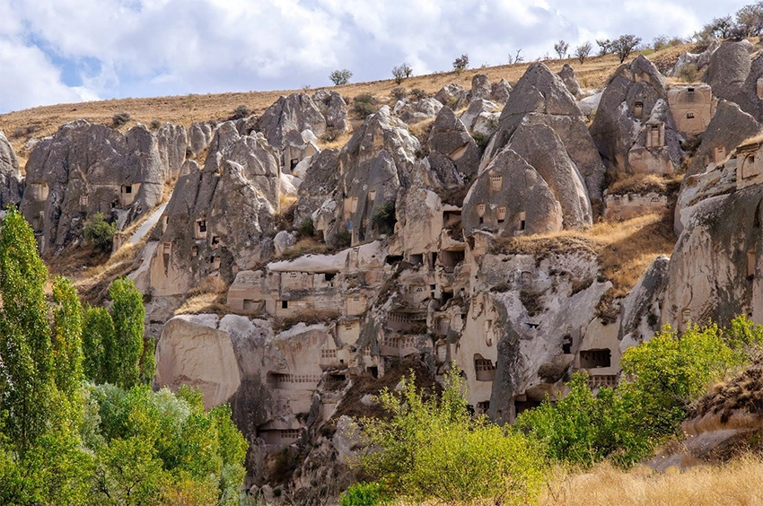
Gomeda Valley begins near Mustafapaşa and gradually changes from a quiet orchard landscape into a narrow world of shadowed rock passages, seasonal water channels and abandoned cave rooms in Cappadocia.
The trail can continue into Üzengi Valley, where the canyon opens and enormous pigeon-house facades cover the cliffs. Together, the two valleys form one of southern Cappadocia's most atmospheric and unpredictable hiking routes.
The safest first visit is a short return walk from the Mustafapaşa side. The complete crossing into Üzengi requires stronger navigation, enough daylight and a confirmed road-accessible pickup point.
Gomeda is not managed like a formal museum path. Mud, reeds, seasonal water, agricultural work and erosion can change the route between visits.
Distance alone does not show the real difficulty. A short overgrown section or unclear stream-bed junction may take longer than several kilometers of open trail.
How to Plan a First Gomeda Valley Hike
Choose between a short return walk and a full one-way crossing before leaving Mustafapaşa. Do not enter with the idea of deciding at every junction.
For a short visit, set a turnaround time and return through the same general corridor. This avoids the remote Üzengi exit and allows the route to be shortened when mud or vegetation becomes difficult.
For a full crossing, save the exact exit point and send it to the driver before entering. The name Üzengi can refer to several rural tracks, springs and roadside areas.
Download offline navigation, carry water and keep a dedicated light available for tunnels. Mobile coverage and visible route markings can weaken inside the narrow valley.
Begin early. The enclosed Gomeda section loses useful light before open roads and upper plateaus, while the broader Üzengi section can still require a long walk to the pickup point.
Why Gomeda Feels Different
Gomeda does not offer the open balloon views or bright panoramic ridges associated with Göreme. Its character comes from enclosure.
Rock walls move closer to the path, trees block parts of the sky and shallow water channels lead into short tunnels. In some sections, the next turn cannot be seen until the trail reaches it.
The silence can feel surprisingly intense. Wind moving through empty cave openings, pigeons calling from high cliffs and water passing beneath vegetation create an atmosphere that feels more isolated than the valley's distance from Mustafapaşa suggests.
The valley's atmosphere comes from geography and land use rather than one famous viewpoint. Orchards, drainage channels, storage spaces and pigeon houses remain close to the walking route.
This also means the trail is not separate from local life. Agricultural tracks may be used by residents, and a quiet field or orchard may still be privately owned and maintained.
Visitors who prefer wide views and simple road access may find Pancarlık or an upper Göreme viewpoint easier. Gomeda rewards slower walking, close observation and tolerance for uncertain ground.
Is Gomeda Valley Haunted?
Gomeda is sometimes described online as Cappadocia's haunted or cursed valley. Its association with local stories, caves and a Turkish horror film helped strengthen this reputation.
There is no evidence that the valley is haunted. The feeling comes mainly from its narrow geography, deep shadows, abandoned rooms and long sections where few other hikers may be present.
Gomeda can feel eerie, especially late in the day, but the real risks are ordinary ones: losing the path, entering an unstable cave, crossing mud or remaining inside the enclosed valley after darkness.
The haunted label should be treated as modern folklore and popular culture, not as historical evidence about the valley's communities or churches.
Do not let the story encourage exploration of closed rooms after dark. Abandoned-looking spaces can contain unstable ceilings, animal roosts, hidden drops and contaminated ground.
Gomeda and Üzengi in One Sentence
Gomeda is narrow, shaded and tunnelled. Üzengi is wider, brighter and dominated by monumental pigeon-house walls.
The transition is gradual, and maps do not always agree on the exact boundary between them.
Gomeda and Üzengi are connected landscapes rather than two sites divided by a marked gate. Route descriptions may place the transition at different bends, springs or pigeon-house groups.
For practical planning, treat Gomeda as the enclosed section and Üzengi as the broader exit landscape. This is more useful than trying to identify one exact boundary on the ground.
How Gomeda and Üzengi Valleys Were Formed
The valleys developed within volcanic deposits created by repeated eruptions across the wider Cappadocia region. Ash, pumice and other material accumulated in layers that later hardened into tuff, tuffite and ignimbrite.
Rainwater, runoff, freezing, thawing and gravity cut channels through weaker sections. Differences in rock hardness and mineral content explain why some walls remain steep while other sections broaden into softer slopes.
The same workable rock allowed communities to carve churches, storage rooms and pigeon houses. It also remains vulnerable to water, fractures and surface erosion.
Fresh debris, newly exposed cracks or collapsed branches can signal recent change. Do not cross rockfall barriers or enter a cavity simply because an older map shows it as part of the route.
Read the guide to the formation of Cappadocia's fairy chimneys for a broader explanation of the region's volcanic layers and erosion.
Why Are There So Many Pigeon Houses?
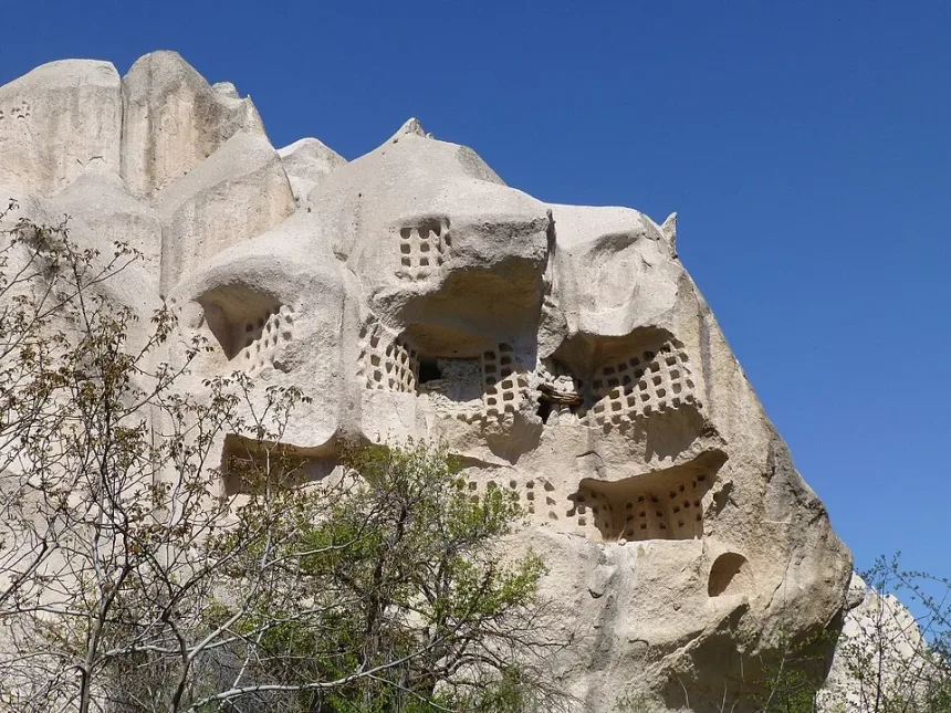
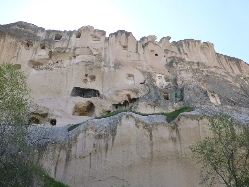
The large facades in Üzengi were not created simply for decoration. Their small openings allowed pigeons to nest inside protected chambers.
Local farmers collected pigeon manure and used it to fertilize vineyards, orchards and cultivated fields. Some facades were painted or arranged in repeated patterns to make the entrances more visible to the birds.
Related Tours
Popular experiences for this destination
 Adventure
Trekking Tours Cappadocia
Hike Cappadocia’s spectacular valleys, fairy chimneys, and cave dwelli…
Vip Mix Tour Cappadocia
Experience the ultimate Cappadocia highlights in comfort-historic vall…
 Blue Tour
Blue Tour Cappadocia
Explore hidden valleys, ancient churches, and cultural gems on Cappado…

Cappadocia Rent A Car
Explore Cappadocia freely at your own pace with flexible car rental op…
 Balloon
Cappadocia Hot Air Balloon Tour
See Cappadocia from the air at sunrise on a professionally operated ho…
 Adventure
ATV Tour Cappadocia
Ride powerful ATVs through Cappadocia’s unique valleys, fairy chimneys…
 Red Tour
Red Tour Cappadocia
Discover Göreme Open-Air Museum, Avanos pottery workshops, and breatht…
 Adventure
Horseback Riding Tour Cappadocia
Experience Cappadocia on horseback, riding through valleys, hidden tra…
Professional Photo Shoot Cappadocia
Capture your Cappadocia moments with a guided professional photo shoot…

Airport Transfer Service Cappadocia
Travel comfortably and safely between Cappadocia’s airports and your h…

Classic Car Tour Cappadocia
Step into nostalgia with a vintage classic car ride through Cappadocia…
Nostalgic Electric Car Tour Cappadocia
Ride eco-friendly nostalgic electric cars through Cappadocia’s valleys…
The scale of these structures reveals how important pigeons were to the agricultural economy. What appears from a distance to be an apartment block carved into the cliff was actually part of a working farming system.
The facades often hide deeper nesting chambers that are not visible from the trail. Small openings helped birds enter while limiting access by larger animals.
Some high entrances may once have been reached by ladders or paths that no longer survive. Their present inaccessibility does not mean the structures were originally isolated.
Use a camera zoom instead of climbing toward the facades. The approach slopes are loose, and repeated foot traffic accelerates erosion.
Pigeon manure was only one part of the agricultural system. Vineyards, fruit trees, storage rooms, water channels and routes back to Mustafapaşa worked together.
Churches and Rock-Cut Heritage
Gomeda contains churches, chapels, storage rooms, shelters and agricultural spaces created during different periods.
Not every opening was religious. Many rooms were reused for animals, food storage, grape processing or pigeon breeding after their original function changed.
One carved space may contain evidence from several phases. A former church could later become storage, while a domestic room could be adapted for animals or pigeons.
Names used on digital maps do not always match historical dedications. Confirm a monument by its location, architecture and current signs rather than relying only on one translated name.
Painted surfaces are vulnerable to moisture and touch. Do not use water to reveal faded pigment, lean against walls or enter beyond a barrier for photographs.
Alakara Church
Alakara Church is one of the best-known religious monuments associated with the valley. Its surviving decoration is fragmentary, and access may not be clearly marked.
Do not enter through an unstable opening or climb across a damaged surface only because a digital map places the church nearby. Current path conditions are more important than an old map marker.
Churches and painted rooms may be closed because of rockfall danger, conservation work or the lack of a safe approach.
The exact dating and original dedication of Alakara should not be overstated without current documentation. Its value lies in the surviving rock-cut architecture and fragmentary decoration within the wider Gomeda settlement landscape.
A nearby map marker does not prove that the entrance is on the same level as the trail. Steep ground, vegetation and private land can separate the visible path from the monument.
When access is uncertain, view the surrounding rock-cut complex from the recognized route and continue. A church visit is not worth crossing unstable ground.
The Dark Tunnels and Cave Rooms
Gomeda includes short rock tunnels, enclosed passages and large cave rooms. Some are natural drainage channels, while others were enlarged for movement, storage or settlement.
The short trail tunnels normally return to daylight quickly. Deeper side chambers are different. Their floors may contain loose rock, mud, animal waste or unprotected drops.
Bats may use quiet cavities, but hikers should not enter deep chambers to search for them. Disturbing a roost can harm the animals and create panic inside an already dark space.
A dedicated light is more useful than holding a phone in one hand. Keep both hands available when the ground is uneven, and turn back when the floor or exit cannot be seen clearly.
These passages should not automatically be described as underground-city tunnels. Some follow natural drainage, while others may have been widened or adapted for movement and water control.
Remove sunglasses and allow your eyes to adjust before entering. Large backpacks can catch on low ceilings or branches.
Let one person complete a narrow passage before the next enters. Crowding makes it harder to turn around when the floor is wet.
Deep side chambers are not part of the normal hiking experience. Their air quality, stability and internal drops cannot be judged from the doorway.
The Thorny Transition Into Üzengi
The path between Gomeda and Üzengi is not always a clean, open trail.
During wetter periods, reeds, long grass and wild blackberry bushes can hide the stream bed and make the route difficult to follow. Mud may cover the ground beneath the vegetation, while branches can force hikers toward the water.
Long trousers are useful on the complete crossing. Shorts leave the legs exposed to thorns and dense vegetation.
Do not force a route through a wall of reeds simply because the GPS line continues forward. Look for the recognized path on slightly higher ground or return to the last clear junction.
GPS accuracy can weaken between close cliffs, so the recorded line may appear inside the stream bed even when the usable path runs several meters higher.
Long trousers and sleeves reduce cuts from blackberry canes and dry branches. Eye protection can also be useful when vegetation crosses face height.
Do not cut plants, move irrigation equipment or create a new route through cultivated ground. Turning back is more responsible than damaging the landscape to preserve a planned track.
Seasonal Water and Mud
Gomeda does not contain one permanently flowing stream with predictable conditions.
The channel may be dry during one visit and muddy or covered by shallow water during another. Rain falling on the surrounding plateau can enter the narrow valley even when the immediate sky appears clear.
Possible conditions include:
- Soft mud beneath reeds
- Shallow stream crossings
- Wet branches used as temporary stepping points
- Loose volcanic soil
- Slippery tunnel floors
- Trail sections damaged by runoff
Do not enter during a thunderstorm or immediately after severe rain. The enclosed sections provide few quick escape routes.
Rain falling on the plateau may reach the narrow channel after a delay. A dry trail at the entrance does not guarantee that deeper sections will remain dry.
Soft mud can conceal stones, holes and branches. Test the ground before placing full weight and avoid stepping from one unstable branch to another.
If water reaches the maintained walking line or begins moving strongly through a tunnel, return to higher ground. Do not attempt an improvised crossing to save time.
Spring is often the greenest period but not necessarily the easiest. Autumn usually provides a clearer route when recent rainfall has been limited.
Mineral Springs in Üzengi
Üzengi is associated with natural mineral-water sources. Near some water points, iron-rich deposits can stain the ground orange or rusty brown.
A noticeable mineral or sulphur smell may also be present. This does not necessarily mean that the water is polluted or that organic material is decaying.
Local traditions sometimes connect the spring water with digestive health. Untreated natural water should not be consumed only because local stories describe it as beneficial.
Water quality, flow and access can change. Do not treat a spring as a guaranteed drinking-water source during the hike.
Mineral staining can vary from one outlet to another and may change with flow. It should not be used by visitors to diagnose water quality.
Health claims about digestion or other conditions are local traditions, not a substitute for laboratory testing or medical advice.
Carry all required drinking water from Mustafapaşa. Natural spring water may contain microorganisms or mineral concentrations unsuitable for some visitors.
Choose the Right Gomeda Route
| Route | Distance and Time | Best For | Main Experience |
|---|---|---|---|
| Short Gomeda Walk | Approximately 3 to 5 kilometers, 2 to 3 hours | Visitors who want the enclosed valley without transport problems | Rock passages, orchards, Alakara area and a return to the same entrance |
| Gomeda to Üzengi Crossing | Approximately 5 to 8 kilometers, 3 to 5 hours | Regular hikers with transport arranged at the exit | Tunnels, mud, reeds, mineral springs and monumental pigeon houses |
The figures are planning ranges rather than official measurements. The selected entrance, church detours, vegetation and pickup location can change the final distance.
A route that appears short on a map may take longer when the stream bed is muddy or overgrown. Plan by daylight and conditions, not only kilometers.
Short Gomeda Walk
The shorter route begins from the Mustafapaşa side, enters the upper or central valley and returns along the same general corridor.
This option avoids the uncertain transport situation at Üzengi and allows hikers to turn back before the stream bed becomes overgrown or difficult.
Choose a return time before entering. The enclosed landscape makes it easy to lose track of how far you have walked.
This route is the better choice when the weather is uncertain, the group has mixed ability or transport has not been arranged.
Select a clear turnaround feature, such as a tunnel, church junction or time limit. Do not continue until the trail becomes difficult and then begin the return tired.
The short route still includes orchards, rock-cut rooms and enclosed passages, so it provides a meaningful introduction without reaching Üzengi.
Gomeda to Üzengi One-Way Crossing
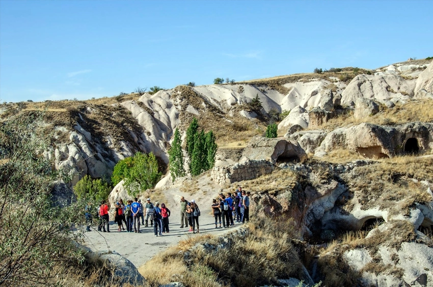
The complete crossing begins near Mustafapaşa, follows the narrowing Gomeda landscape and continues toward the broader Üzengi section.
It is the stronger experience for hikers who want to see the valley change from shaded tunnels and vegetation into open agricultural land and large pigeon-house cliffs.
The main challenge is not the total distance. It is the combination of unclear junctions, mud, vegetation and the remote finishing point.
The crossing should begin in the morning. Allow time for route checks, church detours and a slower final approach to the vehicle.
Do not add every side cave or map marker. Complete the main valley transition first, then stop only at monuments that are clearly open and safely accessible.
Carry food, water, a light and a power reserve for the phone. No business should be treated as guaranteed along the route.
The Üzengi Exit Problem
The Üzengi end of the route may leave hikers beside a rural road or dirt track rather than in a village center with waiting taxis.
Related Tours
Popular experiences for this destination
AdventureTrekking Tours Cappadocia
Hike Cappadocia’s spectacular valleys, fairy chimneys, and cave dwelli…
Vip Mix Tour Cappadocia
Experience the ultimate Cappadocia highlights in comfort-historic vall…
Blue TourBlue Tour Cappadocia
Explore hidden valleys, ancient churches, and cultural gems on Cappado…
Cappadocia Rent A Car
Explore Cappadocia freely at your own pace with flexible car rental op…
BalloonCappadocia Hot Air Balloon Tour
See Cappadocia from the air at sunrise on a professionally operated ho…
AdventureATV Tour Cappadocia
Ride powerful ATVs through Cappadocia’s unique valleys, fairy chimneys…
Red TourRed Tour Cappadocia
Discover Göreme Open-Air Museum, Avanos pottery workshops, and breatht…
AdventureHorseback Riding Tour Cappadocia
Experience Cappadocia on horseback, riding through valleys, hidden tra…
Professional Photo Shoot Cappadocia
Capture your Cappadocia moments with a guided professional photo shoot…
Airport Transfer Service Cappadocia
Travel comfortably and safely between Cappadocia’s airports and your h…
Classic Car Tour Cappadocia
Step into nostalgia with a vintage classic car ride through Cappadocia…
Nostalgic Electric Car Tour Cappadocia
Ride eco-friendly nostalgic electric cars through Cappadocia’s valleys…
Do not assume that a vehicle can be called easily after completing the walk. Mobile reception may be weak, and a driver may not understand which of the Üzengi tracks you have reached.
Before entering Gomeda:
- Save the exact exit point offline.
- Send the location to the driver while reception is available.
- Agree on a pickup time and a road-accessible meeting point.
- Ask the driver to confirm that the selected road can be reached by vehicle.
- Keep the driver's phone number saved outside messaging applications.
A rental car is practical only for a short return walk. On a complete one-way crossing, the car remains at the Mustafapaşa entrance.
Agree on a named landmark, road junction or shared map pin rather than saying only Üzengi exit. Several rural approaches can look similar to a driver.
Confirm the pickup time, waiting policy and price before starting. Vegetation or church stops may delay the group.
Take a screenshot of the driver's phone number, vehicle details and meeting location. Messaging applications may not load when reception is weak.
Üzengi Bridge is one of the recognized heritage structures associated with the Mustafapaşa area, but it should not be assumed to lie directly on every hiking exit. Confirm the route before adding it as a stop.
How Difficult Is the Route?
The short Gomeda walk is manageable for regular walkers under dry conditions. The full crossing becomes more demanding when mud, water and dense vegetation hide the path.
There is normally no need for technical climbing, but hikers may need to step across shallow channels, bend through rock passages and find a route around overgrown ground.
The complete crossing is not a good choice for:
- Visitors uncomfortable in dark enclosed spaces
- People with serious balance or knee problems
- Very young children
- Anyone beginning late in the afternoon
- Hikers without offline navigation
A route requiring dangerous climbing or entry into a deep unsupported chamber is not the normal public path.
Moderate difficulty does not mean consistent ground. The route may feel easy on a dry day and demanding after rain or during peak vegetation growth.
People with knee concerns may find stepping between muddy banks and uneven channels harder than the total distance suggests.
Dogs can struggle with thorns, livestock, tunnels and transport from the remote exit. Do not attempt the full crossing with a dog unless the route is already understood.
The trail is not suitable for wheelchairs or pushchairs. Families with older active children should choose a short return route and remain close around water and cave openings.
Ground and Light Warning
Gomeda requires two things that open Cappadocia viewpoints do not: reliable footing and enough light.
- Expect shoes to become muddy on the complete crossing.
- Use a dedicated light inside dark passages.
- Wear long trousers when reeds and blackberry bushes are dense.
- Complete the route before the enclosed valley loses daylight.
- Do not rely on finding water, food, toilets or an open church inside.
Best Time to Hike
Keep a dry layer in the bag. The shaded Gomeda section can feel cooler than Mustafapaşa, while the open Üzengi exit may be hot and windy.
Save the entrance, exit, driver and hotel information offline. Continuous photography can use the battery needed later for navigation and pickup communication.
Carry a basic first-aid kit for cuts from thorns, blisters and minor falls.
Best Time to Hike
Spring
Spring brings green vegetation, flowering trees and stronger water flow. It also creates the deepest mud and the most difficult reed-covered sections.
Check recent rainfall rather than relying only on the day's forecast. Water and mud can remain after the sky clears.
Summer
Begin in the morning. The narrow valley provides shade, but the open Üzengi section can become hot.
Carry more water than a normal town walk requires. Shade decreases as the route opens toward Üzengi.
Autumn
Autumn usually offers cooler weather and changing color among the trees. Drier ground can make the crossing easier than in spring.
Shorter daylight becomes the main limitation later in the season. Begin the full route early even when temperatures are comfortable.
Winter
Snow and ice can remain inside shaded passages after nearby roads have cleared. Do not enter when the condition of the tunnel floor cannot be assessed.
Snow can hide the distinction between the stream bed and the walking path. Choose a short familiar route or guided walk rather than following an old track blindly.
How to Reach Gomeda Valley
Mustafapaşa is the most practical starting point.
A taxi or private driver can leave hikers near the selected entrance. Show the driver the saved map position because several dirt tracks and agricultural roads exist around the village.
Travelers staying in Ürgüp can reach Mustafapaşa by road and begin the hike from there. Göreme requires a longer transfer.
For the complete crossing, transport from the Üzengi exit should be organized before departure.
Walking from the center of Mustafapaşa adds approach distance. Confirm whether the planned timing begins at the village square or the actual trailhead.
A rental car is convenient for a short return walk but unsuitable for a one-way crossing unless a second driver or transfer is arranged.
Review the guide to getting to and around Cappadocia before comparing a taxi, rental car and private transfer.
Combine Gomeda With Mustafapaşa
A practical plan is to explore Mustafapaşa's central stone streets in the morning and begin a shorter Gomeda walk after the village visit.
Do not combine a detailed Mustafapaşa tour with the complete Gomeda and Üzengi crossing unless enough daylight and return transport have been secured.
Some Cappadocia Blue Tour programs visit Mustafapaşa or nearby southern attractions. A short viewpoint stop should not be confused with a complete Gomeda hike. Confirm the walking distance before booking.
A balanced day usually includes either a detailed village visit with a short Gomeda walk or a quick village introduction followed by the complete crossing.
Allow time for lunch and water before entering. There are no reliable food stops inside the valley.
Read the full Mustafapaşa travel guide when planning the village and valley as one route.
Guided or Independent?
Independent Short Walk
A short return route is possible for hikers with offline navigation and enough daylight.
Turn back when the path becomes unclear, heavily overgrown or dependent on entering an unstable cave.
Independent hikers should be comfortable abandoning the planned endpoint. Returning safely is more important than completing a recorded track.
Guided Gomeda and Üzengi Crossing
The complete crossing is better suited to a guided Cappadocia trekking tour.
A local guide can identify the correct stream-bed connections, avoid blocked passages and organize transport from the remote Üzengi exit.
This is not a route where a guide is valuable only for historical commentary. Local route knowledge can determine whether the walk ends comfortably at the meeting vehicle or beside the wrong dirt road.
Ask whether the guide includes upper or lower transport, church interpretation and route changes after rain. A fixed program should not be followed when current conditions make it unsafe.
A guided crossing is particularly useful in spring, when reeds and water can hide the normal connection between Gomeda and Üzengi.
Responsible Visiting
Places to Visit Near Gomeda and Üzengi
Mustafapaşa
Mustafapaşa preserves stone mansions, churches, a madrasa and historic streets. It is the most natural cultural stop before a short Gomeda hike.
Ürgüp
Ürgüp provides restaurants, accommodation and easier transport connections after the hike.
Pancarlık Valley
Pancarlık Valley offers colored volcanic layers and rock-cut churches in a more open rural setting.
Soğanlı Valley
Soğanlı Valley lies farther south and combines village landscapes with a separate group of rock-cut churches.
Do not add all nearby places to the same hiking day. Gomeda and Üzengi require flexible time because route and pickup conditions can change.
Common Gomeda and Üzengi Planning Mistakes
- Starting without an exit pin: Üzengi has several rural tracks and meeting areas.
- Planning only by distance: Mud, reeds and tunnels can slow a short route considerably.
- Following the GPS line through vegetation: The usable path may run on higher ground.
- Relying on mineral springs: Carry safe drinking water from the start.
- Expecting every church to be open: Access may change because of stability and conservation.
- Entering deep side caves: They may contain drops, unstable roofs and animal roosts.
- Beginning late: Gomeda loses light earlier than open plateau routes.
- Combining a full village tour with the complete crossing: The result is usually rushed.
- Waiting until the exit to call a taxi: Reception and vehicle access may be limited.
Responsible Visiting
- Do not enter deep, dark or unsupported cave systems.
- Do not disturb bats or other animals using the cavities.
- Do not touch frescoes or carved crosses.
- Stay out of cultivated orchards and fields.
- Do not drink untreated spring water based only on local health claims.
- Do not enter during heavy rain or thunderstorms.
- Carry all trash out of the valley.
- Finish the hike before darkness.
Frequently Asked Questions About Gomeda and Üzengi
Review the Cappadocia safety and essentials guide before attempting the full route independently.
Questions Travelers Ask About Gomeda and Üzengi
Is Gomeda Valley haunted?
There is no evidence that Gomeda is haunted. Its reputation comes from folklore, popular culture, deep shadows, abandoned caves and its isolated atmosphere.
How long is the Gomeda hike?
A short return route is approximately 3 to 5 kilometers. The complete Gomeda and Üzengi crossing may cover approximately 5 to 8 kilometers.
How much time do you need?
Allow two to three hours for a short Gomeda walk and three to five hours for the complete one-way crossing.
Are there bats inside the caves?
Bats may use quiet rock cavities. Do not enter deep chambers or disturb a roost to search for them.
Are the tunnels completely dark?
Some short passages still receive light from their exits. Deeper side rooms can be completely dark and should not be entered without clear, safe access.
Are there mineral springs in Üzengi?
Üzengi is associated with mineral-water sources and iron-rich staining. Untreated spring water should not be assumed safe to drink.
Is the trail muddy?
It can be. Spring rain and seasonal water may create mud, shallow crossings and overgrown stream-bed sections.
Can you return easily from the Üzengi exit?
Not without planning. Arrange a driver and share the exact meeting point before beginning the one-way hike.
Do you need a guide?
A guide is not essential for a short return walk. It is strongly useful for the complete Gomeda and Üzengi crossing because of navigation and transport problems.
Is Gomeda Valley suitable for children?
A short dry section may suit older active children under close supervision. Tunnels, mud, thorns and the remote exit make the complete crossing unsuitable for very young children.
Is mobile reception reliable?
Reception can weaken inside enclosed sections. Save the route, driver details and meeting point before entering.
Can you hike after rain?
A short route may remain possible, but mud, runoff and hidden stream channels can make the crossing unsafe. Avoid the valley during storms and check recent conditions.
Are there toilets or cafés inside the valley?
No reliable facilities should be expected. Use toilets and purchase water and food in Mustafapaşa before starting.
Can Gomeda be combined with Ihlara Valley?
Not comfortably as detailed hikes on the same day. Ihlara Valley requires a separate western Cappadocia route and substantial driving time.
How Gomeda and Üzengi Fit Into a Cappadocia Itinerary
Gomeda is not memorable because of one famous formation. Its character develops slowly as orchards give way to tunnels, dark cave openings, seasonal water and overgrown passages.
Üzengi changes the atmosphere again. The valley opens, sunlight returns and enormous pigeon-house facades reveal the scale of the agricultural system that once supported the surrounding settlements.
The complete route is less polished than Cappadocia's busiest trails. That is exactly why it remains one of the region's most rewarding walks for travelers prepared to deal with mud, uncertainty and a remote exit.
The route is strongest when understood as a connected cultural landscape rather than a collection of caves. Orchards, water channels, churches, storage rooms and pigeon houses belonged to the same working environment.
A careful visit separates folklore from documented history, public paths from private agricultural land and short trail tunnels from unsafe deep cavities.
For most first-time visitors, Mustafapaşa and a short Gomeda return walk create a balanced half-day. The complete Üzengi crossing is better reserved for hikers with early timing, current route knowledge and confirmed pickup transport.
Use the Cappadocia trip planning guide to combine Gomeda with nearby southern sites without turning the day into a race.