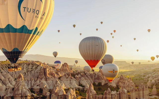
Pancarlik Valley
Pancarlık Valley Cappadocia Guide
Pancarlık Valley is a quiet volcanic landscape south of Ortahisar, between Ürgüp and Mustafapaşa. Its appeal comes from layered yellow, cream, pink and reddish slopes, cultivated vineyards and a rock-cut Byzantine church in Cappadocia.
This is not a valley for collecting famous landmarks. Pancarlık is most rewarding when you slow down, examine the changing rock colors and notice how the church, pigeon houses and agricultural land belong to the same rural landscape.
Pancarlık works best as a church visit combined with a short rural walk. It is not necessary to follow every dirt track or search for every remote rock-cut structure to understand the valley.
The final road, church access and trail conditions can change. A vehicle, saved map pin and flexible schedule are more useful here than a tightly timed list of stops.
Visitors should expect a working countryside rather than a managed open-air museum. Agricultural vehicles, safari groups, private fields and locally supervised monument access may all affect the visit.
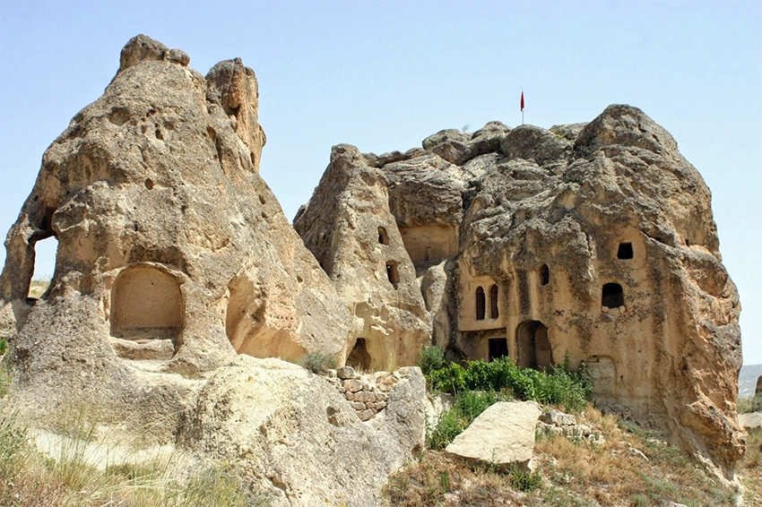
How to Plan a First Visit to Pancarlık Valley
Navigate to Pancarlık Church rather than using only the valley name. The church is the clearest practical reference for the approach road, parking area and start of the short walking route.
Allow at least 60 to 90 minutes for the church and immediate landscape. Two hours provide a more comfortable pace for photography, a rural walk and possible waiting time at the entrance.
Confirm church access before traveling specifically for the frescoes. Opening arrangements, admission and local supervision may change without appearing immediately on older travel pages.
Wear shoes with grip and carry water. The main track is usually manageable in dry weather, but soft volcanic soil becomes muddy after rain and shaded surfaces may remain icy in winter.
Choose a turnaround point before following longer agricultural roads. These extensions are less consistently marked and may cross private land or lead away from the church parking area.
Why Visit Pancarlık Valley?
- Fewer organized groups: Pancarlık usually feels quieter than the major valleys around Göreme.
- Layered volcanic color: Cream, yellow, pink and red surfaces change noticeably under low sunlight.
- Pancarlık Church: The valley contains an important rock-cut church with surviving Byzantine paintings.
- Short walking options: The principal landscape can be experienced without a full-day hike.
- Living agricultural scenery: Vineyards, orchards, pigeon houses and cultivated plots remain visible.
- Southern Cappadocia route: Pancarlık fits naturally between Ortahisar, Ürgüp and Mustafapaşa.
Where Is Pancarlık Valley?
Pancarlık is most suitable for travelers interested in Byzantine painting, geology, rural photography and quieter southern Cappadocia routes. Visitors seeking a long marked trek may find Gomeda, Rose Valley or Ihlara more appropriate.
Where Is Pancarlık Valley?
Pancarlık lies south of Ortahisar, close to the countryside road network between Ürgüp and Mustafapaşa.
The final approach may include an uneven or unpaved section. Navigate directly to Pancarlık Church rather than using only a general valley marker, because map applications may show different points for the church, parking area and walking tracks.
Regular public transport should not be expected. A taxi, rental car, private driver or customized regional tour is the practical way to reach the valley.
The road distance may appear short from Ürgüp or Mustafapaşa, but the final approach can be slower than a normal paved-road journey. Allow time for navigation, uneven ground and agricultural traffic.
Do not ask a taxi to return at an approximate time without sharing the exact pin. Mobile reception can weaken on rural tracks, and several roads in the area look similar.
When driving, park without blocking field entrances, tractors or wider safari routes. A quiet roadside space may still be used for agricultural access.
What Does Pancarlık Valley Look Like?
Pancarlık does not contain the dense capped fairy chimneys of Paşabağ or the deep canyon walls of Ihlara. Its landscape is formed by soft, rolling volcanic ridges cut into waves, shallow gullies and exposed bands of color.
The effect resembles a small badlands landscape. Rainwater and surface runoff removed softer material while revealing layers with different mineral content and resistance.
At midday, the slopes can appear pale and almost flat. During the final hours of daylight, the same ridges gain stronger yellow, orange, pink and red tones as shadows move across their curved surfaces.
The visible bands developed within volcanic deposits created during different eruptive phases. Ash, pumice and other material accumulated in layers that later hardened into tuff, tuffite and ignimbrite.
Rainwater, runoff, freezing, thawing and gravity removed weaker material at different rates. Differences in mineral content, porosity and hardness helped create the changing surface colors and rounded ridges.
The colors should not be explained by one mineral alone. Oxidation, weathering, moisture and changing light all affect how the slopes appear.
Erosion is still active. Do not climb directly onto narrow ridges, cross fresh debris or stand beneath fractured rock for photographs.
Read the guide to the formation of Cappadocia's fairy chimneys for more information about volcanic deposits, erosion and changing rock layers.
Pancarlık Church
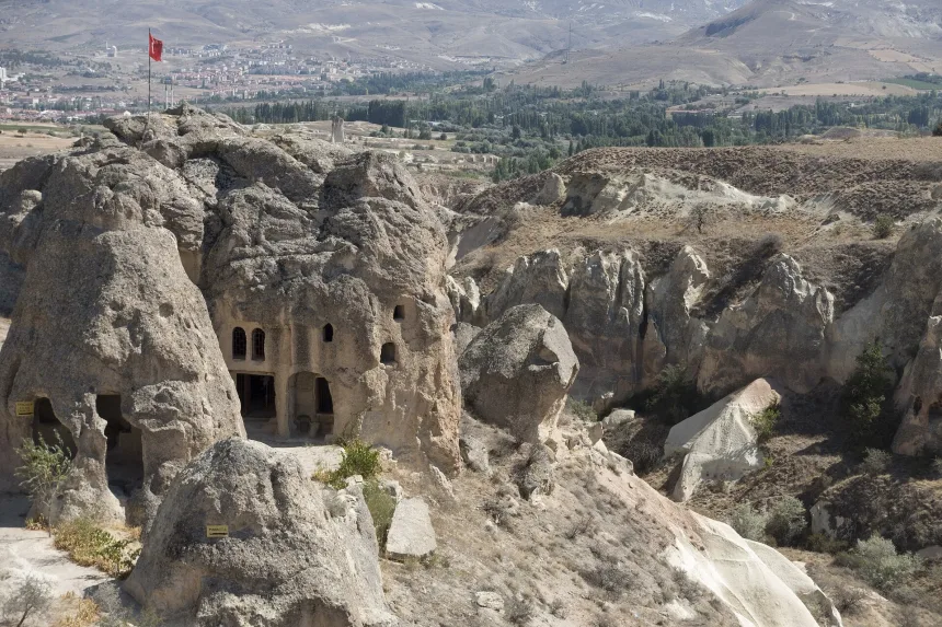
Pancarlık Church is the valley's main historical monument. It was carved directly into the volcanic rock and formed part of the Byzantine Christian landscape surrounding Ortahisar, Ürgüp and the southern Cappadocia villages.
Related Tours
Popular experiences for this destination
 Adventure
Trekking Tours Cappadocia
Hike Cappadocia’s spectacular valleys, fairy chimneys, and cave dwelli…
Vip Mix Tour Cappadocia
Experience the ultimate Cappadocia highlights in comfort-historic vall…
 Red Tour
Red Tour Cappadocia
Discover Göreme Open-Air Museum, Avanos pottery workshops, and breatht…
Classic Car Tour Cappadocia
Step into nostalgia with a vintage classic car ride through Cappadocia…
 Blue Tour
Blue Tour Cappadocia
Explore hidden valleys, ancient churches, and cultural gems on Cappado…
Nostalgic Electric Car Tour Cappadocia
Ride eco-friendly nostalgic electric cars through Cappadocia’s valleys…
 Adventure
ATV Tour Cappadocia
Ride powerful ATVs through Cappadocia’s unique valleys, fairy chimneys…
 Adventure
Horseback Riding Tour Cappadocia
Experience Cappadocia on horseback, riding through valleys, hidden tra…
Professional Photo Shoot Cappadocia
Capture your Cappadocia moments with a guided professional photo shoot…
 Adventure
Jeep Safari Tour Cappadocia
Take an off-road jeep adventure across Cappadocia’s rugged landscapes,…
 Green Tour
Green Tour Cappadocia
Explore Derinkuyu underground city, the beautiful Ihlara Valley, and S…
Turkish Night Show Cappadocia
Enjoy a traditional Turkish dinner with live music, folk dances, and w…
The church contains painted scenes connected with Christ, the Virgin Mary, saints and angels. The decoration belongs to the wider Cappadocian tradition of transforming carved interiors into carefully organized religious spaces.
The architecture and paintings may represent more than one phase of use. It is safer to understand the church as a structure that was carved, decorated and possibly altered over time rather than assigning every visible element to one exact year.
Pancarlık Church is also recorded among the significant monumental buildings associated with the Mustafapaşa conservation landscape. This places the church within a wider network of protected religious and civil architecture rather than treating it as an isolated rural cave.
The modern name identifies the location, but it should not be used to invent an original dedication. Historical church names, local names and map labels do not always preserve the same information.
Read the plan before focusing only on paintings. Entrances, apses, carved divisions and later alterations help explain how the space was used and changed.
Not every visible mark belongs to the first painting phase. Smoke, moisture, later scratches and repairs can overlap the original decoration.
Look for the Green Fresco Backgrounds
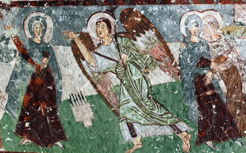
Visitors often expect Cappadocian churches to be dominated by red ochre, brown and cream. Inside Pancarlık Church, surviving sections also contain noticeable green areas that create a different visual character.
The colors should be observed as part of the complete painted programme rather than treated as one isolated curiosity. Look at how green, red, cream and darker outlines are used to separate figures, clothing and background areas.
Moisture, smoke, surface loss and human contact have affected the paintings. Do not touch the walls or lean against decorated surfaces.
Photography rules may depend on current site management. Where photography is permitted, avoid flash near the frescoes.
Green pigment can appear stronger in photographs than it does under low interior light. Allow your eyes to adjust before judging the color balance.
Do not use a bright phone light directly against painted surfaces. A low, indirect light is more respectful when current rules permit illumination.
The surviving program should be interpreted as a complete religious interior, not as a color-themed attraction. Figures, gestures, inscriptions and scene placement matter as much as the background tones.
Paint loss can make individual scenes difficult to identify confidently. Avoid assigning a subject from one damaged fragment without supporting context.
Read the guide to Christianity in Cappadocia for the broader history of Byzantine churches, monastic communities and rock-cut religious art.
Is Pancarlık Church Open?
Access arrangements can change. The church may operate with local supervision, limited visiting periods or separate admission conditions.
Do not rely on an old blog post for opening hours, entrance prices or Museum Pass acceptance. Confirm the current situation before travelling specifically for the church interior.
Even when the interior is closed, the exterior and surrounding landscape remain useful for understanding how the church was placed within the rural environment.
A closed door should not be bypassed through another opening. Alternative entrances may lead across unstable rock or into areas not prepared for visitors.
When access is available, allow people to exit before entering. The interior is confined, and crowding increases the chance of contact with painted walls.
Current opening hours, admission prices and Museum Pass treatment are variable information. Check them close to the visit rather than building the entire day around an old source.
How Much Time Do You Need?
| Area or Activity | Approximate Time | Difficulty | Main Experience |
|---|---|---|---|
| Pancarlık Church | 20 to 40 minutes | Easy | Rock-cut architecture and surviving Byzantine paintings |
| Church and Short Valley Walk | 1 to 2 hours | Easy under dry conditions | Layered slopes, vineyards, pigeon houses and rural scenery |
| Extended Rural Exploration | 2 to 3 hours | Easy to moderate | Longer tracks toward agricultural land and nearby rock-cut remains |
| Ala and Kepez Area | Allow additional time | Moderate and route-dependent | More isolated religious structures with uncertain access |
These times are planning ranges rather than official visit limits. Waiting for access, taking photographs and walking from a different parking position can extend the visit.
The Ala and Kepez area should be treated as an optional guided extension, not as a required part of a first Pancarlık visit.
Short Pancarlık Valley Walk
Pancarlık is better suited to a relaxed landscape walk than a long-distance trek.
A practical route begins near the church, follows the visible rural track into the valley and returns through the same general area. This provides enough time to see the colored ridges, agricultural plots and pigeon houses without entering uncertain side paths.
The route is generally straightforward under dry conditions. Rain can turn the soft soil into mud, while winter shade may leave ice on less exposed tracks.
Longer dirt roads continue toward cultivated land and neighboring valleys. These extensions are not always marked as formal hiking trails.
An out-and-back route is the simplest option because the vehicle remains near the church. Turn around before the path becomes an unclear farm road or descends into a separate valley system.
Look back regularly while walking. The church, parking area and main ridges are easier to identify from the outward route than during the return from an unfamiliar branch.
After rain, choose firm existing ground rather than walking around mud through cultivated plots. Creating a new line damages both fields and fragile volcanic surfaces.
There are no reliable water points or toilets along the extended tracks. Use facilities before leaving Ürgüp, Ortahisar or Mustafapaşa.
Ala Church and Kepez Church
Ala Church and Kepez Church are associated with the wider Pancarlık countryside, but they should not be presented as guaranteed stops on a standard church visit.
Their approaches may cross less obvious rural tracks, agricultural land or areas affected by erosion. Access and structural condition can change.
These monuments are better suited to visitors travelling with a local guide or someone who knows the current route. Do not enter a damaged cavity or cross private fields only because a digital map places a church nearby.
Their names may appear at slightly different positions across mapping platforms. A map marker should be treated as a reference, not proof of a maintained approach.
Remote churches can contain unstable ceilings, loose entrances and unprotected drops. Current ground conditions are more important than completing a historical checklist.
When these churches are the main interest, arrange a guide who can confirm access before the visit. Do not expect a driver who knows Pancarlık Church to know every side path.
The Safari Traffic Reality
Pancarlık is regularly described as completely silent. That can be true, but not at every hour.
Some wider tracks around the valley may be used by local ATV, horse-riding or off-road safari operators. Activity often increases later in the day when sunset tours leave the surrounding towns.
The exact routes and departure hours change between operators, seasons and local access decisions. A fixed daily time cannot be guaranteed.
Vehicle tracks do not necessarily identify the best walking route. Some lead to agricultural areas, photography stops or neighboring valleys.
When a vehicle or horse group approaches, move to firm ground beside the track and wait for dust to clear. Do not step onto a soft slope or cultivated field simply to avoid the group.
Motorized traffic can increase dust and surface erosion. Visitors should remain on recognized walking ground and operators should use only authorized routes.
When Is Pancarlık Quietest?
Morning and early afternoon generally provide the best chance of walking without safari traffic.
Late afternoon offers stronger colors but may also bring vehicles, horses and dust onto the wider valley-floor tracks.
Visitors arriving for photography should remain on recognized pedestrian ground near the church and avoid standing in the center of a track used by moving tour groups.
Weekends, holidays and good-weather sunset periods can be busier than normal weekdays. Quiet should be presented as likely, not guaranteed.
Morning is usually better for church-focused visits because the road and walking tracks are less dusty and there is more time to resolve changing access.
Is Pancarlık Valley Good for Sunset?
Yes. Pancarlık is one of southern Cappadocia's most attractive low-key sunset landscapes.
The valley does not have one famous platform comparable with Kızılçukur. Its strength comes from the way low sunlight moves across many small ridges at once.
The pink and yellow slopes become more three-dimensional as shadows form between the folds. Vineyards and fruit trees provide darker foreground elements that make the volcanic colors appear stronger.
Pancarlık can therefore offer a calmer alternative to the crowded road viewpoints around Göreme and Red Valley, although complete solitude should never be guaranteed.
Related Tours
Popular experiences for this destination
AdventureTrekking Tours Cappadocia
Hike Cappadocia’s spectacular valleys, fairy chimneys, and cave dwelli…
Vip Mix Tour Cappadocia
Experience the ultimate Cappadocia highlights in comfort-historic vall…
Red TourRed Tour Cappadocia
Discover Göreme Open-Air Museum, Avanos pottery workshops, and breatht…
Classic Car Tour Cappadocia
Step into nostalgia with a vintage classic car ride through Cappadocia…
Blue TourBlue Tour Cappadocia
Explore hidden valleys, ancient churches, and cultural gems on Cappado…
Nostalgic Electric Car Tour Cappadocia
Ride eco-friendly nostalgic electric cars through Cappadocia’s valleys…
AdventureATV Tour Cappadocia
Ride powerful ATVs through Cappadocia’s unique valleys, fairy chimneys…
AdventureHorseback Riding Tour Cappadocia
Experience Cappadocia on horseback, riding through valleys, hidden tra…
Professional Photo Shoot Cappadocia
Capture your Cappadocia moments with a guided professional photo shoot…
AdventureJeep Safari Tour Cappadocia
Take an off-road jeep adventure across Cappadocia’s rugged landscapes,…
Green TourGreen Tour Cappadocia
Explore Derinkuyu underground city, the beautiful Ihlara Valley, and S…
Turkish Night Show Cappadocia
Enjoy a traditional Turkish dinner with live music, folk dances, and w…
Sunset color depends on clouds, haze and the direction of the final light. The strongest tones may appear before the sun reaches the horizon.
The valley is not organized around one official sunset platform. Choose a firm, already used position with a clear route back to the vehicle.
Begin returning before complete darkness. Unpaved roads, field entrances and soft slopes become harder to distinguish after the final light.
The Best Photography Direction
The strongest compositions are often found by walking a short distance beyond the immediate church area on the recognized track and then looking back across the layered slopes.
A slightly elevated position helps separate the yellow, pink and cream ridges. Remaining on firm, already used ground is safer than climbing directly onto soft volcanic formations.
During golden hour, use the church, vineyards or pigeon houses as scale references rather than photographing only the empty rock.
Drone use depends on current aviation rules, protected-area restrictions, private land and local enforcement. Do not assume that an open landscape automatically permits drone flight.
A moderate zoom is useful for pigeon houses and distant church facades. It reduces the temptation to climb onto unstable rock for a closer composition.
Tripods should not block the church entrance or vehicle tracks. Move equipment when local residents, agricultural vehicles or visitors need to pass.
Do not step backward while framing a ridge or facade. Soft edges and shallow gullies can be difficult to see when attention remains on the camera screen.
Vineyards and Rural Life
Pancarlık remains part of a cultivated landscape rather than an abandoned natural park.
Vineyards, orchards and agricultural plots are visible around the valley. Grapes supported several products, including fresh fruit, raisins, grape molasses, juice and wine.
Rock-cut rooms could provide stable conditions for storing tools, fruit and agricultural products. Other spaces were used for animals or grape processing.
The fields beside the trail may still belong to local families. Do not pick grapes or fruit, move farming equipment or cross planted ground to shorten the route.
Seasonal pruning, harvesting and irrigation can change which track appears most obvious. Follow local directions and give workers enough space.
Rock-cut storage rooms and agricultural structures should not be entered automatically. Some remain privately used, while others have weakened through erosion.
Grape cultivation connects Pancarlık with the wider food and wine history of Ürgüp and Mustafapaşa. The valley should be read as productive land, not only as a photography background.
Pigeon Houses
Pigeon houses were carved into elevated rock faces so birds could nest above the agricultural land.
The main value of the pigeons was not meat or decoration. Their manure was collected and used as fertilizer in vineyards, orchards and fields.
These facades are part of the valley's agricultural history. Their small openings, internal chambers and elevated position were designed around a practical farming system.
Painted or patterned entrance areas may have helped birds identify the nesting facade. The designs should not be interpreted as decoration without considering this practical function.
High chambers may once have been reached through ladders or access paths that no longer survive. Do not attempt to recreate that access by climbing.
Pigeon houses, vineyards and fruit plots formed one connected agricultural system. Their relationship is easier to understand from a wider landscape view than from one opening alone.
How to Reach Pancarlık Valley
From Ortahisar
Pancarlık is reached through local countryside roads south of Ortahisar. The journey is short by vehicle, but the final approach may include uneven ground.
From Ürgüp
The valley is a short countryside drive from Ürgüp. Taxi, rental car or private tour is more practical than attempting to use public transport.
From Mustafapaşa
Pancarlık can be combined easily with Mustafapaşa. The two locations create a strong half-day route connecting Byzantine heritage, stone mansions and rural scenery.
Navigation Tip
Search for Pancarlık Church rather than only Pancarlık Valley. The church normally provides a more precise navigation target than a general valley pin.
Save the route before leaving the main road because mobile reception and map accuracy may become less reliable on countryside tracks.
Download both the outward road and the return route. A navigation application may choose a different unpaved road after the visit.
For a taxi visit, agree on waiting time and the exact pickup position before the driver leaves. Calling a new vehicle from the valley may take longer than expected.
Check road conditions after heavy rain or snow. A normal car may not be suitable for every final approach when the surface is soft or icy.
Review the guide to getting to and around Cappadocia when comparing taxis, rental cars and private transport.
A Strong Half-Day Southern Cappadocia Route
- Morning: Explore the historic streets and monuments of Mustafapaşa.
- Late morning: Continue by vehicle to Pancarlık Valley.
- Church visit: See Pancarlık Church when current access allows.
- Landscape walk: Follow a short rural track through the colored ridges.
- Afternoon: Continue to Ortahisar or return to Ürgüp.
This route works because the locations are geographically connected. It avoids unnecessary travel back through central Göreme.
The order can be reversed in summer. Visiting Pancarlık Church early, then exploring Mustafapaşa near lunch, reduces heat and makes church access easier to confirm.
Choose either a detailed Mustafapaşa visit or a longer Pancarlık walk. Attempting both in depth can turn a half-day route into a rushed schedule.
Ürgüp is the easiest place to finish for restaurants and evening activity, while Mustafapaşa suits travelers who prefer a quieter village atmosphere.
Private Tour or Independent Visit?
Independent Visit
A rental car works well for Pancarlık Church and a short return walk.
The main disadvantages are the uneven final road, uncertain church access and the difficulty of locating more remote structures such as Ala and Kepez without local information.
Save the church pin and return road before departure. Independent visitors should be willing to skip an interior or side monument when access is unclear.
Customized Southern Cappadocia Tour
A customized Cappadocia Blue Tour can combine Mustafapaşa, Pancarlık Valley and other southern Cappadocia sites.
Not every standard Blue Tour includes Pancarlık. Confirm the exact church stops, walking time and entrance arrangements before booking.
A Private Cappadocia Mix Tour offers more flexibility for combining Pancarlık with Ortahisar, Mustafapaşa and Ürgüp without following a fixed group schedule.
Ask whether the program includes an interior church visit, a short landscape walk or only a roadside photo stop. These are very different experiences even when Pancarlık appears in the itinerary.
Entrance fees and local access should be confirmed separately. A private vehicle does not guarantee that a closed church can be opened.
Common Pancarlık Valley Planning Mistakes
- Searching only for the valley name: The church pin is a more reliable navigation target.
- Expecting guaranteed church access: Local supervision, conservation and opening arrangements can change.
- Following every dirt road: Longer tracks may lead through active agricultural land.
- Arriving only at the listed sunset minute: The strongest color may appear earlier.
- Assuming complete silence: Safari, horse and agricultural traffic may use wider tracks.
- Climbing onto colored ridges: Soft volcanic surfaces are fragile and may conceal unstable edges.
- Visiting Ala and Kepez without route knowledge: Access can be unclear and unsafe.
- Relying on public transport: A taxi, car, driver or tour is normally required.
- Walking after darkness: Rural tracks and the final road are difficult to identify in low light.
Responsible Visiting
- Remain on existing tracks and firm ground.
- Do not touch frescoes or use flash when prohibited.
- Do not enter closed or unstable rock-cut spaces.
- Do not climb pigeon-house facades or volcanic ridges.
- Do not pick fruit or cross planted fields.
- Give agricultural vehicles, horses and safari groups enough space.
- Carry all trash out of the valley.
- Avoid extended tracks during storms, heavy rain, snow or ice.
- Finish the rural walk before darkness.
- Review the Cappadocia safety and essentials guide before visiting independently.
Questions Travelers Ask About Pancarlık Valley
Is Pancarlık Valley worth visiting?
Yes. Pancarlık is a strong choice for travelers interested in Byzantine frescoes, volcanic color and a short rural walk away from Cappadocia's busiest sites.
How long do you need?
Allow around one hour for the church and immediate landscape. Two to three hours are suitable for a slower walk and photography.
Is Pancarlık Valley difficult?
The principal tracks are generally easy under dry conditions. Mud, loose volcanic soil and unmarked extensions can increase the difficulty.
Is Pancarlık Church open every day?
Access conditions may change. Confirm current opening arrangements before travelling specifically for the interior paintings.
Are the frescoes inside Pancarlık Church green?
Surviving areas include noticeable green tones alongside red, cream and darker colors. Their visibility depends on preservation, lighting and current access.
Is Pancarlık good for sunset?
Yes. Low evening light strengthens the yellow, pink and orange layers, creating a quieter alternative to Cappadocia's major sunset viewpoints.
Is Pancarlık always quiet?
No. ATV, horseback and other safari groups may use wider tracks, particularly around late-afternoon tour periods.
Can you reach Pancarlık by public transport?
Regular direct public transport should not be expected. Taxi, rental car, private driver or organized tour is more practical.
Can Pancarlık and Mustafapaşa be visited together?
Yes. They form one of the most logical half-day combinations in southern Cappadocia.
Can you visit Ala and Kepez churches independently?
Possibly, but access and route conditions are uncertain. A local guide is useful for locating them without crossing private or unsafe ground.
Is Pancarlık Valley suitable for children?
The short dry route near the church can suit families when children remain close to an adult. Soft slopes, vehicle tracks and unprotected rock-cut openings require supervision.
Are there toilets or cafés in the valley?
Reliable facilities should not be expected beside the walking route. Use facilities and purchase water before leaving the nearby towns.
Can Pancarlık be combined with Gomeda Valley?
Yes, but only as a selective route. A short Pancarlık visit can precede a short Gomeda Valley walk, while the complete Gomeda and Üzengi crossing needs a separate schedule.
Is mobile reception reliable?
Reception may weaken on rural tracks. Save the road, church pin, driver details and return route before arriving.
Can you visit after rain?
The church area may remain reachable, but soft soil, mud and road conditions can affect the walk. Avoid longer tracks when the ground is unstable.
How Pancarlık Valley Fits Into a Cappadocia Itinerary
Pancarlık's value does not come from one monumental formation. It comes from the relationship between colored volcanic ridges, Byzantine painting, vineyards, pigeon houses and the countryside connecting Ortahisar with Mustafapaşa.
The valley can be visited quickly, but staying longer reveals why the church was not isolated from daily life. It stood within a working agricultural landscape shaped by grapes, orchards, animals and seasonal movement.
Pancarlık is strongest as part of a southern Cappadocia route rather than a detour from a crowded central itinerary. Mustafapaşa, Ürgüp and Ortahisar provide the most logical road connections.
A careful visit separates the documented church and landscape from uncertain remote monuments, treats access information as variable and respects the agricultural land surrounding the trail.
For most first-time visitors, the church and a short return walk provide a more complete experience than driving from one distant map marker to another.
Use the Cappadocia trip planning guide to combine Pancarlık with Ortahisar, Ürgüp and Mustafapaşa without turning the southern route into unnecessary driving.