Love Valley
Love Valley Cappadocia Guide
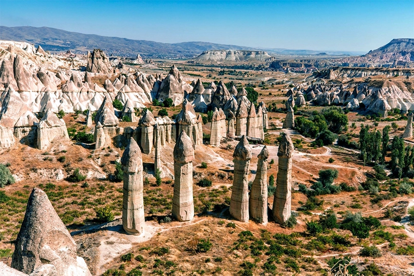
Love Valley is one of the most recognizable landscapes in Cappadocia. Its tall, narrow fairy chimneys rise from vineyards and soft volcanic slopes between Göreme, Çavuşin and Uçhisar.
Most visitors know the valley from photographs taken at the upper panorama. The actual hiking trail is somewhere else. Understanding this difference before leaving Göreme prevents the most common Love Valley mistake.
For a first visit, decide whether the goal is a quick panorama stop, a short valley-floor walk or a longer White Valley crossing. These are separate plans with different entrances, transport needs and time requirements.
The lower route is an agricultural and natural walking landscape rather than a formal open-air museum. Trail conditions, private land boundaries and visible paths can change after rain or seasonal farm work.
The safest planning method is to save both the entrance and intended exit before leaving the hotel. Searching only for Love Valley can lead to the wrong side of the landscape.
How to Plan a First Visit to Love Valley
Choose the experience before arranging transport. The upper panorama is road accessible, while the lower trail begins from a different approach and cannot be reached safely by descending directly from the viewpoint.
For a short walk, use an out-and-back route from the lower trailhead. This avoids the need for a second vehicle and allows the group to turn around when heat, mud or time becomes a concern.
For the complete White Valley and Love Valley crossing, arrange a drop-off near Uçhisar and a pickup near the lower exit. Save both points offline and share them with the driver.
Carry water, sun protection, shoes with grip and a phone battery reserve. Reliable toilets, cafés and drinking water should not be expected on the valley floor.
Start early in hot weather and keep a daylight margin for the return. The lower route becomes shaded before the upper panorama, and junctions are harder to identify in low light.
Why Is Love Valley Famous?
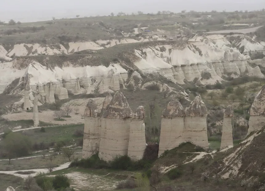
Love Valley is famous for its unusually tall cylindrical fairy chimneys. Some formations have narrow bodies and rounded upper sections, while others retain harder caps that slow the erosion of the softer rock below.
The modern English name refers to the distinctive appearance of these formations. The valley is also associated with the local name Bağlıdere.
The pillars were not shaped during one eruption or by wind alone. Water, surface runoff, frost, gravity and differences in rock resistance gradually separated them from the surrounding volcanic deposits.
The formations developed within volcanic and sedimentary layers that do not erode at the same rate. Harder material can protect softer rock below, while vertical cracks help divide the remaining mass into narrow bodies.
Some of the cylindrical forms northwest of Göreme are associated with thick sedimentary sections beneath smaller ignimbrite caps. This helps explain why Love Valley pillars differ from the more conical formations seen elsewhere.
The shape continues to change. Cap loss, surface weathering and erosion around the base can gradually weaken an individual pillar even when the wider group appears permanent.
Do not stand directly below fractured surfaces or climb onto the bases. Fresh debris and narrow cracks can indicate continuing erosion.
Read the guide to the formation of Cappadocia's fairy chimneys for the full geological explanation.
Love Valley Panorama and Love Valley Trail Are Not the Same Place
This is the most important detail in the entire guide.
Love Valley Panorama is the upper roadside viewpoint with cafés, swings, heart-shaped decorations and wide views over the formations.
Love Valley Trail is the lower hiking route that passes between vineyards, fruit trees and the bases of the giant rock pillars.
The two locations provide completely different experiences and are reached from different directions.
The panorama and lower trail may appear close in a straight line, but steep terrain separates them. Road distance and safe walking distance are more important than the visual gap.
A combined visit normally requires driving from one access point to the other. Do not plan to leave a vehicle at the panorama and return from the valley floor without a transport arrangement.
Use separate saved map labels such as Love Valley Panorama and Love Valley Hiking Trailhead. This avoids confusion with drivers, hotels and other members of the group.
The Panorama Trap
Do not ask a driver only for Love Valley when your real plan is to hike.
Related Tours
Popular experiences for this destination
 Balloon
Balloon Watching Tour Cappadocia
Watch the magical sight of hundreds of hot air balloons rising at sunr…
 Balloon
Cappadocia Hot Air Balloon Tour
See Cappadocia from the air at sunrise on a professionally operated ho…
 Adventure
Trekking Tours Cappadocia
Hike Cappadocia’s spectacular valleys, fairy chimneys, and cave dwelli…
Vip Mix Tour Cappadocia
Experience the ultimate Cappadocia highlights in comfort-historic vall…
 Red Tour
Red Tour Cappadocia
Discover Göreme Open-Air Museum, Avanos pottery workshops, and breatht…
Professional Photo Shoot Cappadocia
Capture your Cappadocia moments with a guided professional photo shoot…
 Adventure
Horseback Riding Tour Cappadocia
Experience Cappadocia on horseback, riding through valleys, hidden tra…

Airport Transfer Service Cappadocia
Travel comfortably and safely between Cappadocia’s airports and your h…

Classic Car Tour Cappadocia
Step into nostalgia with a vintage classic car ride through Cappadocia…
 Adventure
Jeep Safari Tour Cappadocia
Take an off-road jeep adventure across Cappadocia’s rugged landscapes,…

Pottery Workshop Cappadocia
Learn the ancient art of pottery from Avanos masters, try shaping clay…

Cappadocia Rent A Car
Explore Cappadocia freely at your own pace with flexible car rental op…
Many drivers and map applications will direct visitors to the upper panorama because it is the best-known vehicle-accessible location. From there, the fairy chimneys appear close enough to reach on foot.
The steep volcanic slopes below the panorama are not the normal hiking entrance. Do not attempt to descend an unmarked line from the cliff edge toward the valley floor.
The loose tuff surface can break beneath the feet, and a route that looks possible from above may end at a vertical drop or unstable slope.
For the lower trail, ask specifically for the Love Valley hiking trailhead or show the driver the exact saved entrance point near the Göreme and Çavuşin road network.
Wait until the driver confirms the lower entrance before leaving the vehicle. A nearby dirt road may lead to a farm, another valley branch or a viewpoint with no safe descent.
Do not follow social media footage of people descending directly from the panorama. Camera angles hide slope steepness, loose surfaces and dead ends.
When the correct entrance is uncertain, choose the panorama as a separate road stop and return later with a confirmed hiking route.
What to Expect at Love Valley Panorama
The panorama is useful for visitors who want a quick view without completing a hike. It offers a broad perspective over the valley and is easy to reach by taxi, rental car or tour vehicle.
It is also one of Cappadocia's most commercial viewpoints.
Visitors may find:
- Decorative swings and heart-shaped photo installations
- Small cafés and refreshment stands
- Souvenir sellers
- Managed photography areas
- Parking or privately operated sections with separate charges
The natural view remains impressive, but visitors expecting a silent wilderness viewpoint may be surprised by music, tour vehicles and organized photo sessions.
The panorama is best treated as a short scenic stop, not as the starting point of the valley-floor hike.
Charges, parking arrangements and business hours are controlled by individual operators and can change. Confirm current conditions close to the visit rather than relying on an old price photograph.
The viewpoint can become crowded around sunrise and late afternoon. Keep away from unsupported edges and do not step backward while framing photographs.
Swings and decorative platforms are commercial installations, not part of the natural valley. Use them only according to current staff instructions and displayed rules.
Why Walk on the Valley Floor?
The panorama shows the complete landscape, but the lower trail reveals the real scale of the formations.
From the valley floor, the pillars rise directly above the path. Their size is difficult to understand from the upper viewpoint because distance compresses the landscape.
The lower route also passes through vineyards, orchards and working agricultural land. Love Valley is not only a collection of unusual rocks. It has been cultivated and used by local communities for generations.
Some rock-cut openings were used for storage, animals or pigeon breeding. Not every cavity was a home or religious space.
High openings may once have been reached by wooden ladders, terraces or sections of rock that no longer survive. Their present inaccessibility is part of the erosion history.
Stay on the existing walking line around vineyards and fruit trees. A quiet field still belongs to someone, and apparent shortcuts can damage irrigation channels or planted ground.
Pigeon houses, storage rooms and vineyards should be viewed as one agricultural system. The valley was productive land long before it became a photography destination.
Livestock guardian dogs may be present near fields or animals. Do not run, shout, feed them or approach livestock. Keep calm, remain with the group and move away slowly.
Choose the Right Love Valley Experience
| Route or Location | Approximate Time | Difficulty | Best For |
|---|---|---|---|
| Love Valley Panorama | 15 to 30 minutes | Very easy | Wide views, quick photographs and a road-accessible stop |
| Valley Floor Out-and-Back Walk | 1 to 2 hours | Easy to moderate | Seeing the giant fairy chimneys from below without completing a long route |
| White Valley and Love Valley Crossing | 3 to 4 hours | Moderate | A longer one-way hike connecting Uçhisar, Bağlıdere and the Love Valley formations |
These times are planning ranges rather than official route measurements. The exact trailhead, detours, mud and pickup point can change the final duration.
Distance alone does not describe difficulty. A short loose descent or unclear agricultural junction can take longer than a wider section of valley floor.
Short Love Valley Floor Walk
The short route enters from the lower trailhead and follows the valley toward the main pillar formations.
This is usually planned as an out-and-back walk. Visitors can continue until they have seen the principal formations and then return to the same entrance.
The route is useful for travelers who want to experience the valley at ground level without arranging transport at a second exit.
Allow one to two hours depending on the starting point, walking speed and time spent around the formations.
Set a turnaround time before entering. The giant pillars can appear close while bends, vineyards and side channels add distance.
The short route is the best choice for families, uncertain weather and visitors without return transport. It still provides the strongest ground-level view of the main formations.
After rain, avoid walking around mud through cultivated plots. Turn back when the maintained path becomes waterlogged or difficult to identify.
Do not continue into a steep or narrow connector simply because another group used it. They may be following the longer White Valley route.
White Valley and Love Valley Route
The strongest complete hike combines White Valley with Love Valley and the Uçhisar landscape.
White Valley is also connected with the name Bağlıdere on some maps. Local route names are not always used consistently, so hikers should focus on the confirmed entrance, exit and direction rather than relying on one valley label.
A common one-way plan begins near the lower slopes of Uçhisar Castle and continues through pale volcanic channels toward Love Valley.
Starting from the Uçhisar side generally creates more descending terrain than walking the same route in reverse. It is not completely downhill. The trail may still contain loose slopes, narrow passages and short climbs.
The route normally requires three to four hours, depending on the exact trailhead, detours and finishing point.
The White Valley label is not used consistently across maps. Some route descriptions apply Bağlıdere to the complete corridor, while others use it only for one branch.
Focus on the confirmed Uçhisar trailhead, the Love Valley formations and the lower road exit rather than trying to match every local name on the ground.
The route includes pale channels, orchards, loose slopes and sections where the valley narrows. It should not be described as continuously downhill or technically effortless.
Carry enough water for the full crossing. Seasonal cafés and roadside stands are not reliable supply points on the hiking route.
Why Start From Uçhisar?
Beginning near Uçhisar offers three advantages:
- More of the route follows the natural descent toward the lower valley.
- White Valley and Love Valley can be experienced as one continuous landscape.
- The walk can finish closer to the flatter road network between Göreme and Çavuşin.
Transport to the starting point should be arranged in advance. The driver must be shown the exact trailhead because several dirt roads and valley entrances exist below Uçhisar.
Ask the driver to wait until the entrance is identified. Being left at the nearest panoramic pull-off can create an unsafe or confusing start.
Save a second trailhead option in case construction, agricultural activity or erosion affects the intended entrance.
People with knee concerns should not assume the Uçhisar direction is easier simply because it descends overall. Loose downhill surfaces can place greater strain on joints.
How to Return After the One-Way Hike
The White Valley and Love Valley crossing should not be planned like a circular town walk.
Before starting, decide where the hike will finish and how you will return to Göreme or Uçhisar.
The practical options are:
- Arrange a taxi pickup from the lower road exit.
- Ask the hotel to organize the starting transfer and finishing collection.
- Join a guided one-way trekking route with transport included.
- Use two vehicles when travelling as a larger group.
Send the finishing location to the driver before entering the valley. Do not describe the meeting point only as Love Valley because the panorama, lower entrance and trail exits are separate places.
Related Tours
Popular experiences for this destination
BalloonBalloon Watching Tour Cappadocia
Watch the magical sight of hundreds of hot air balloons rising at sunr…
BalloonCappadocia Hot Air Balloon Tour
See Cappadocia from the air at sunrise on a professionally operated ho…
AdventureTrekking Tours Cappadocia
Hike Cappadocia’s spectacular valleys, fairy chimneys, and cave dwelli…
Vip Mix Tour Cappadocia
Experience the ultimate Cappadocia highlights in comfort-historic vall…
Red TourRed Tour Cappadocia
Discover Göreme Open-Air Museum, Avanos pottery workshops, and breatht…
Professional Photo Shoot Cappadocia
Capture your Cappadocia moments with a guided professional photo shoot…
AdventureHorseback Riding Tour Cappadocia
Experience Cappadocia on horseback, riding through valleys, hidden tra…
Airport Transfer Service Cappadocia
Travel comfortably and safely between Cappadocia’s airports and your h…
Classic Car Tour Cappadocia
Step into nostalgia with a vintage classic car ride through Cappadocia…
AdventureJeep Safari Tour Cappadocia
Take an off-road jeep adventure across Cappadocia’s rugged landscapes,…
Pottery Workshop Cappadocia
Learn the ancient art of pottery from Avanos masters, try shaping clay…
Cappadocia Rent A Car
Explore Cappadocia freely at your own pace with flexible car rental op…
Agree on a road-accessible meeting point, approximate time, waiting policy and price. A live location sent from inside the valley may not be precise enough for a vehicle.
Save the driver's phone number, vehicle details and pickup pin in a screenshot. Mobile reception and messaging applications can become unreliable near enclosed sections.
Keep one flexible hour in the plan. Navigation mistakes, photography and slower group members can delay the finish.
Can You See Hot-Air Balloons From Love Valley?
Yes, but not every morning.
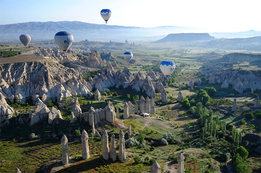
Love Valley is widely promoted as a sunrise balloon location because flights sometimes pass above or close to the formations. Photographs can make this look like a guaranteed daily scene.
Balloon routes depend on wind direction, launch decisions, landing requirements and official aviation approval. On some mornings, the balloons may cross the valley. On others, they may remain closer to Göreme or move toward a different part of Cappadocia.
A weather application cannot predict the exact flight path reliably enough to guarantee that balloons will appear directly over the pillars.
Visitors whose only goal is seeing many balloons may find the central Göreme viewpoints more reliable because they overlook a wider section of the principal flight region.
Read the Cappadocia hot-air balloon guide before choosing a sunrise location.
The upper panorama is more practical than the lower trail before dawn because it is road accessible and easier to leave when balloons move elsewhere.
Entering an unfamiliar valley floor in darkness adds footing and navigation risk without improving the guarantee of balloon views.
Balloon-free mornings can still provide useful sunrise light on the formations. The visit should not be judged only by whether aircraft cross directly overhead.
Sunrise or Sunset?
Sunrise at the Panorama
Sunrise provides soft light and the possibility of seeing balloons. The upper viewpoint can become busy with photography groups before the sun appears.
Morning on the Valley Floor
Morning is the better time for walking. The lower trail is cooler, and the sunlight gradually reaches the formations as it rises above the surrounding ridges.
Late Afternoon
Late-afternoon light adds warmer tones to the rock, but Love Valley does not produce the same intense red color associated with Kızılçukur.
Complete longer routes with enough daylight remaining. The lower valley becomes shaded before the upper panorama.
Late afternoon is better for a short walk than a full one-way crossing unless transport and timing are already secure.
Sunset should be viewed from a road-accessible area after leaving the trail. Do not remain beside the pillars until darkness and then attempt to identify the lower exit.
Strong wind can make exposed panorama edges uncomfortable even when the valley floor feels calm. Carry a light layer outside midsummer.
Is Love Valley Free?
The natural hiking landscape generally does not operate as a ticketed archaeological museum.
The upper panorama may contain privately managed parking, cafés, photo installations or commercial areas with their own charges.
A charge at the panorama does not mean that every Love Valley trail requires an entrance ticket. Likewise, free access to the natural valley does not include permission to enter private agricultural land.
Natural access can still be affected by local closures, construction, land use or safety work. Free does not mean unmanaged or guaranteed.
Do not move gates, cut fences or cross a vineyard to reconnect with a GPS line. Return to the last visible public path.
Commercial photography areas and agricultural land may have separate rules from the natural walking corridor.
How to Reach Love Valley From Göreme
For the Panorama
A taxi, rental car or tour vehicle is the simplest option. Tell the driver that you want the upper Love Valley Panorama.
For the Lower Trail
Show the driver the exact Love Valley trailhead rather than the panorama. Walking from central Göreme is possible, but the road approach adds distance before the natural route begins.
For the Uçhisar Route
Arrange a taxi to the selected trailhead below Uçhisar and confirm the final pickup point near the lower Love Valley exit.
Offline navigation is valuable because agricultural tracks and valley branches can appear similar.
Download both the outward and return roads. Navigation applications may choose a different unpaved approach when recalculating after the hike.
Walking from central Göreme adds road exposure and should be included in the distance estimate. Use the quieter recognized approach rather than following the fastest vehicle road blindly.
Review the guide to getting to and around Cappadocia when comparing a taxi, rental car and guided transfer.
Love Valley With a Local Hiking Guide
Love Valley is easy to photograph but less simple to walk as a complete one-way route.
The main problems are choosing the correct entrance, avoiding the panorama trap, identifying the White Valley connection and arranging transport from the finishing point.
A guided Cappadocia trekking tour can combine White Valley, Love Valley and Uçhisar without requiring visitors to solve the route and transport separately.
A private guide is especially useful for travelers who want to understand the geology, agricultural history and rock-cut spaces rather than treating the valley only as a photograph stop.
Ask whether the service includes the Uçhisar transfer, lower pickup and route adjustment after rain. A guide without transport may still leave the group with a one-way logistics problem.
Independent hikers should be willing to turn back. Completing a recorded route is less important than keeping enough daylight and avoiding private land.
Places to Combine With Love Valley
Uçhisar Castle
Uçhisar Castle is the natural starting or finishing point for a longer White Valley and Love Valley hiking day.
Rose and Red Valleys
The Rose and Red Valleys offer a more complex trail network with churches, vineyards and the Kızılçukur sunset landscape.
Göreme Sunset Point
Göreme Sunset Point overlooks Göreme from a separate ridge. It is not the same place as Love Valley Panorama.
Çavuşin
Çavuşin is close to the northern road network and can be combined with a short Love Valley walk. Its old settlement and churches require additional climbing, so allow separate time.
Do not combine the full White Valley crossing with several other long valley walks on the same day. Choose one major hike and use nearby sites as short road or village stops.
Walking Conditions and Seasonal Planning
Spring
Vineyards and orchards become greener, but rain can create mud and soft channel floors. Check recent conditions, not only the forecast for the current hour.
Summer
Begin early, carry enough water and use sun protection. Shade is limited around several pillar groups and upper White Valley sections.
Autumn
Cooler temperatures and generally drier ground often suit longer walks. Daylight becomes shorter later in the season.
Winter
Snow creates strong contrast around the formations, but ice can remain on shaded slopes after roads and panoramas have cleared.
Photography Without Damaging the Valley
Use a moderate zoom to photograph high openings and cap details. Climbing the pillar bases damages soft rock and creates unnecessary fall risk.
Tripods should not block the walking line or agricultural tracks. Move equipment when workers, animals or other hikers need to pass.
Drone use depends on current aviation, protected-area and local restrictions. An open valley should not be treated as automatic permission.
Do not carve names, place objects on formations or move stones to create a cleaner composition.
Common Love Valley Planning Mistakes
- Using one map pin for every plan: The panorama and lower trail have different access points.
- Descending from the upper viewpoint: The steep slopes are not the normal hiking route.
- Starting a one-way hike without pickup transport: The finish may be far from the starting vehicle.
- Expecting guaranteed balloons: Flight paths depend on wind and official decisions.
- Following every dirt track: Some routes enter farms, private land or another valley branch.
- Planning only by distance: Loose slopes and route-finding can change the difficulty.
- Waiting for sunset on the valley floor: The lower route loses useful light earlier.
- Climbing the formations: Soft volcanic rock is fragile and unstable.
Questions Travelers Ask About Love Valley
How long should you spend in Love Valley?
Allow 15 to 30 minutes for the panorama, one to two hours for a short valley-floor walk and three to four hours for the White Valley crossing.
Is the panorama the hiking entrance?
No. The upper viewpoint and lower trail are separate locations. Do not descend directly from the panorama.
Is Love Valley suitable for children?
The panorama and a short dry valley-floor walk can suit families with close supervision. The complete crossing is better for older active children with hiking experience.
Are there toilets or cafés on the trail?
Facilities may exist at the upper commercial panorama, but reliable toilets, cafés and drinking water should not be expected on the lower route.
Can you hike after rain?
A short section may remain possible, but mud, runoff and loose surfaces can make longer routes unsafe. Turn back when the trail becomes difficult to identify.
Is Love Valley the same as Bağlıdere?
Bağlıdere is a local name associated with the valley network, but map usage is inconsistent. Plan with exact entrances and exits rather than relying only on the name.
Can Love Valley and Rose Valley be walked on the same day?
A short Love Valley walk can be combined with a selected section of the Rose and Red Valleys. Completing both major routes in one day is tiring and creates transport problems.
How Love Valley Fits Into a Cappadocia Itinerary
The upper panorama explains the shape of Love Valley, but the lower trail explains its scale.
Walking beneath the pillars reveals how narrow their bases are, how the formations rise from cultivated land and how erosion continues to change the valley.
The best Love Valley experience is not standing beside a decorative swing. It is understanding the difference between the commercial viewpoint above and the volcanic landscape below.
For most first-time visitors, the best balance is a short panorama stop followed by a separate lower out-and-back walk. The complete White Valley crossing is better reserved for hikers with confirmed transport and enough daylight.
The valley is most meaningful when geology, agriculture and route logic are considered together. The pillars did not develop as isolated sculptures, and the trail does not exist separately from vineyards and working land.
A careful plan prevents the panorama trap, avoids unsafe descents and gives the lower formations enough time to be experienced at their real scale.
Use the Cappadocia trip planning guide to combine Love Valley with Göreme, Uçhisar and nearby valleys without unnecessary transfers.